The Mount Tamalpais Scenic Railway has 260 Curves, Aggregating 25,913 feet, out of a Total Distance of 42,520 feet (8·19 miles), Making it the Crookedest Railway in the World
RAILWAYS OF AMERICA - 12

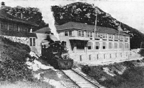
THE SUMMIT TERMINUS OF “THE CROOKEDEST RAILWAY IN THE WORLD”. The Tavern of Tamalpais, 244 feet below the crest. In climbing the mountain the locomotive pushes the train, and in the descent precedes the cars, in accordance with the general operating practice upon each scenic mountain line.
THE scarred lip of California thrusting itself southward, as if to meet that protruding northward, thus forming the famous Golden Gate, has a striking individuality. Topographically the two peninsulas have nothing in common. That to the south is relatively flat, and forms an ideal foundation for the city of San Francisco, which, in its expansion, has not reached out across the marine highway to embrace the northern shore. As the result the latter is much as Nature left it, which, doubtless, is the true reason for its irresistible attraction.
On the northern arm, ragged mountain and deep winding valley alternate, while in its innermost recess nestles the National Forest - Muir Wood - offering the only surviving virgin tract of Californian big trees readily accessible from a teeming city. Over this forest frowns Mount Tamalpais, the fabled shrine of the Tamal Indian tribes, whose name is thus perpetuated, and on the crest of this, 2,600 feet above the Pacific, the United States Government has planted one of its observatories.
The mountain has been a popular rendezvous of San Franciscans since the city was brought into being, but its summit was only attainable to the hardy and venturesome because of the arduousness of the climb. Owing to its elevation above the seas of fog which come drifting in from the Pacific, and the clarity of the atmosphere, the mountain-top became famed far and wide as an eyrie for the enjoyment of scenic splendour, and so it is scarcely surprising that the proposal for the construction of a railway to its crest should have been launched, and enthusiastically endorsed by the lovers of Nature. The scheme was vaguely discussed for some years, but in 1895 it assumed tangible form by the survey of the mountain slopes for the Mill Valley and Mount Tamalpais Scenic Railway.
Construction was commenced on February 5, 1896, and six months later the last rail was truly laid. The road is of standard gauge and 8·19 miles in length. The lower terminus is at Mill Valley, a short distance from Sausalito, lying in a nook at the extreme end of the peninsula on San Francisco Bay. Mill Valley lies 75 feet above the sea, and the upper terminus at the Tavern of Tamalpais is at an altitude of 2,353 feet - that is, 244 feet below the crest occupied by the observatory.
The configuration of the mountainside is somewhat rugged and scarred by deep rifts, which the engineer skilfully avoided to reduce bridging. Owing to the limited space at his disposal, the railway-builder had to advance his line in a bewildering maze of twists and turns, and these constitute the outstanding features of constructional interest.
By confining the climb to the one face instead of spirally ascending the mountain, the pathfinder reduced the mileage to an appreciable degree, and yet kept the grade within the limits of adhesion-working, albeit with a special type of locomotive. The average gradient throughout the entire length of the line is approximately 1 in 20, with a maximum rise or ruling grade of 1 in 14·3. Compensation for grade on the curves, that is allowance for the loss by friction, and the maintenance of a uniform load on the engine, was adopted so far as the circumstances would permit, but it was found impossible to follow any stated rule. All the tangents have a rise of 1 in 14·3, while the reduced grade on the curves rarely falls below 1 in 25. The difficulties confronting the engineer may, perhaps, be more readily appreciated when it is related that five-eighths of the total length of the line is laid on curves, and the minimum radius adopted is 70 feet.

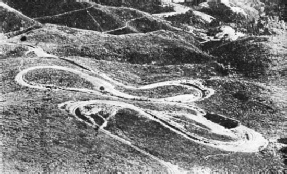
THE “DOUBLE BOW KNOT”. This outstanding engineering feature of the Mt. Tamalpais and Muir Woods Scenic Railway occurs about half-way up the mountain. The track doubles and redoubles upon itself five times in a distance of 3,000 feet to overcome 100 feet of altitude.
The Mount Tamalpais line has been humorously described as “The Crookedest Railway in the World”, and the jest is justified. There are twenty curves of 70 feet radius, totalling 3,641 feet; twenty-four of 80 feet, aggregating 2,974 feet; twenty of 90 feet, giving 2,328 feet; forty-nine of 10 feet, amounting to 4,020 feet; forty-six varying from no to 150 feet radius, or 4,403 feet in all; fifty-nine ranging from 150 to 300 feet, representing 4,710 feet; and forty-two of 300 or more feet, making 4,710 feet. This gives no fewer than two hundred and sixty curves, totalling 25,913 feet out of a total distance of 42,520 feet.
In working out his curves the American railway engineer favours the “degree” - the three-hundred-and-sixtieth part of a circle - as his unit; a curve is thus expressed as of so many degrees. The British method is to use the chain - 66 feet - as the unit, so that a curve is defined as of so many chains (or feet) radius. For the purpose of easy calculation one degree is accepted as equal to a radius of 5,730 feet. So, to convert the number of degrees of curvature into its equivalent radius in feet it is only necessary to divide the unit, 5,730 feet, by the number of degrees expressed.
All the tables prepared for the assistance of the American railway plotter are accordingly based upon the degree unit, but when the engineer who was plotting the Mount Tamalpais railway embarked upon the laying out of his curves, he found both the “degree” unit and published tables useless. Accordingly, he abandoned this practice entirely, in favour of a special tabulation which he prepared. In this he used a chord of 25 feet as the unit, with radii increases in 10-feet lengths, and occasionally subdivisions of 5 feet for the curves ranging from 70 to 300 feet radius, to facilitate his task. Long chords were calculated and used to advantage, especially where ravines had to be crossed, where the total curvature often exceeds 180 degrees.
The longest stretch of straight or “tangent” throughout the 8·19 miles is less than 500 feet in length. About half-way up the mountain the surveyor encountered his greatest difficulty. It was necessary to overcome an abrupt difference of 100 feet in vertical height. It so happened that, at the point to which the engineer had brought his line, the contour of the mountain slope had undergone a wondrous change. In the distant past a mighty shiver of the earth caused Mount Tamalpais to split, and one side to slip down en masse into a large deep ravine, completely filling the latter, and changing the lie of the land by presenting a tolerably flat surface where originally there had been an ugly fissure.
The engineer pressed this slope into service by laying down the line in the form of a double figure “8”. It is colloquially known as the “Double Bow-Knot” from its resemblance to this form when viewed in plan. In ascending the mountain the train swings up the outer edge of the knot, describes a complete semicircle to run back upon itself to the opposite end of the knot, where it makes another semicircular sweep and again doubles upon itself for a run once more to the end of the loop, cuts another half-circle, parallels its previous course, and, describing a final semicircle, continues its sinuous course up the mountain.
The knot is 3,000 feet in length from one end to the other, and the track parallels itself five times, overcoming the total 100-feet difference in level in five steps. At the waist of the double knot it is possible to throw a stone across four tracks. This is the outstanding engineering achievement upon the Mount Tamalpais railway, and constitutes the engineer’s alternative to a switchback.
When first built the road was carried across the rifts on twenty-one wooden trestles, totalling 1,703 feet in length, but they have all been buried. Thus the former springy, creaking, spidery sections of the road have been converted into substantial earthen embankments. Except where the railway drives across the fissures, the whole of the constructional work was side-hill excavation, and the permanent way, with 30-feet steel rails weighing 56 to 62 lb. per yard laid upon sleepers, or ties, spaced 30 inches apart centre to centre, is carried on a shelf of the solid rock forming the body of the mountain. Guard rails are placed on all curves with tie- or fish-plates and rail braces, a method of construction that gives great stability to the line.
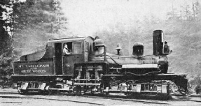
The motive power comprises eight-wheeled Shay geared locomotives; in these the power developed by the cylinders is transmitted through an external shaft on which are keyed pinions meshing with racks disposed circumferentially on each driving wheel. The latter are disposed in two groups, four forward under the engine, and four at the rear beneath the tender, so that all wheels are drivers, and the total weight of the unit becomes available for adhesion. The driving shaft is fitted with universal couplings, so that the locomotive rounds the sharpest curves with ease and safety.

THE SHAY GEARED LOCOMOTIVE. It is an oil-burner driven by an external shaft carrying pinions meshing with bevel wheels mounted on each of the eight driving wheels. It weighs 36 tons and can move a maximum load of 51¼ tons up the mountain. The average running speed is about 8 miles an hour.
The locomotive weighs approximately 36 tons, and is capable of moving a maximum load of 51¼ tons up the mountain. The running speed is a little in excess of 8 miles an hour. For controlling the train, straight and automatic Westinghouse air-brakes are fitted, as well as a set of hand-brakes. The smoke nuisance, as well as all risk of fire from sparks, is overcome by the use of oil-burning engines.
The normal load comprises two open observation cars of the American type, which add to the enhanced pleasure of travel by affording an unobscured view from the train on all sides; the use of liquid fuel greatly facilitates this amenity. In the ascent the locomotive is coupled to the rear of the train; whereas in the descent it heads the train in accordance with the practice generally observed on mountain railways.
At the “Double Bow-Knot” there is junction with another line which has been built during more recent years into the National Forest, or Muir Woods. The completion of this extension caused the original title of the railway to be changed to the Mount Tamalpais and Muir Woods Railway. This branch carries the traveller into the redwood preserve sandwiched between Mount Tamalpais and its continuous hump falling sheer into the sea. Leaving the “Double Bow-Knot” this line follows a tortuous and gradually descending route across the face of the mountain to the south-west, passing through a deep cut to enter Sequoia Canyon.
A few years ago the thrill and delight of the mountain trip was increased by the introduction of a novel alternative method of descent - by “gravity” car. These are coaches of the open observation type, broadly reminiscent of those used upon motor chars-à-bancs, capable of seating twenty-five passengers, and mounted on bogie trucks. As the name implies, they travel under gravitational energy, and are kept under control by a double system of hand-brakes. They are run at a speed of 10 to 12 miles an hour, and, although this may seem somewhat high for tobogganing such a sinuous track into the redwood forest, they have proved completely safe.

A THRILL IN RAILWAY TRAVEL - THE GRAVITY RIDE INTO MUIR WOODS. The cars, mounted on bogie trucks and carrying 25 passengers, are kept under control by a double set of brakes while tobogganing from 10 to 20 miles and hour.
The “coast” is generally regarded as the most exciting and attractive phase of the visit to the mountain-top, and the majority of visitors prefer this method of descent because of its novelty and the excitement arising from the sawing through the glades and swinging around the curves. The cars are run singly; when pressure of traffic demands the services of two or more cars an adequate headway is maintained between them to avoid risk of collision.
This scenic railway is one of the most popular attractions on the North Pacific Coast. During the year thousands of travellers journey to the crest of the mountain to enjoy the magnificent vistas unfolded from more than half a mile above the ocean. Owing to the extreme clearness of the atmosphere points of interest forty or more miles distant, including the snowcapped Sierras, are plainly visible. The splendour and glory of the Pacific sunsets attract vast crowds, and a large proportion of these spend the night on the mountain-top to witness the rise of the sun over the towering glacier and snow-crowned rampart to the east.
Although the Mount Tamalpais railway is essentially for the holiday-seeker and tourist, it is occasionally called upon to perform sterner duty. A few years ago one of the largest fires which have ever ravaged the western American forests broke out upon the densely wooded slopes of the mountain. It raged with fierce intensity for five days and nights, reducing 6,000 acres of magnificent growing timber to gaunt, charred, blackened stumps.
When the alarm was sounded the railway was immediately pressed into service as the only channel offering direct rapid communication with the ravaged area. The supreme danger was that the gigantic redwoods in the National Forest would become engulfed, together with the small outlying towns around the foot of the mountain, and the hamlets and home-steads dotting its slopes. To fight the fire the railway moved three thousand soldiers, sailors and civilians impressed for duty by the authorities up the mountain, and brought back those living in the advancing path of the flames with such goods and chattels as could be rescued. For 120 hours the trains were run continuously; the traffic also included the movement of the huge supplies for the maintenance of those fighting the fire.
In the hope of arresting the fire, which even threatened the railway, a back-fire trail, 50-feet wide, was cut by 2,000 men, but owing to the breeze this gap was jumped with ease by the solid wall of flame several miles in length. During this strenuous period the gravity cars were in steady request as they offered the speediest descent of the mountain. Grave risks were run, and the speed limit was freely exceeded, but the reputation of the road, which boasts no serious accident to any traveller during its twenty-eight years of operation, was not marred, although there were many thrills, minor mishaps and highly exciting dashes to the lowlands when the situation compelled a general precipitate retreat. But for the railway the fire would have ravaged an enormous slice of the mountain-side, and doubtless would have been accompanied by a heavy death-roll.

AERO VIEW OF MOUNT TAMALPAIS AND ITS WONDERFUL CROOKED RAILWAY. By this winding road the traveller is lifted to a height of 2,353 feet above the Golden Gate.
You can read more on
“The First Mountain Railway”,
“Rack Rail Locomotives” and
“The Shay Geared Locomotive”
on this website.


