

Trains in Siam
A survey of an extensive narrow-
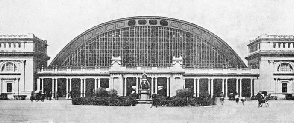
BANGKOK STATION, terminus of the Northern lines of Siam. The present system of the Royal Siamese State Railways radiates from the capital, and the first railway in the country also began at Bangkok. The railways own some 160 locomotives, 300 passenger cars, 3,200 freight wagons and numerous other vehicles, including fifteen Diesel locomotives and six Diesel-
THE story of Siam goes back at least to the fifth century BC. According to tradition, the Siamese king is descended from Buddha, whose temples and statues now enrich Muang Thai, as the natives call their country -
The Chakri dynasty was founded in 1782 on the site of the present capital at Bangkok. In 1820 intercourse with Europe, China, and Japan, which had been interrupted in the 17th century, was renewed, and various trading agreements were subsequently drawn up with foreign powers.
Siam, which is over a thousand miles in length, and nearly five hundred miles wide, presents valuable opportunities for trade. The area is about 195,000 square miles, and the population 11,506,000. The principal product and export is rice, which is also the most important item of food for the Siamese. The teak industry is also important, the trees growing in the mountainous districts in the north of Siam. A third source of national revenue is minerals; gold, tin, copper, and precious stones are found in the country.
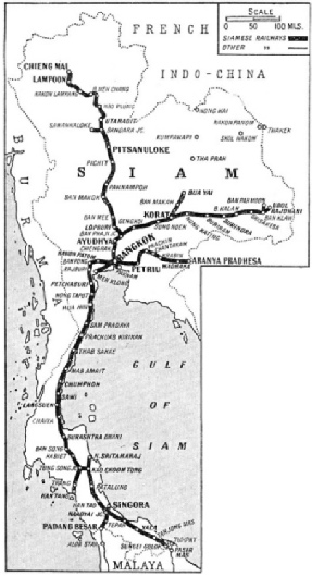
THE PIONEER LINE in Siam, begun in 1891, was laid between Bangkok and Paknam, a distance of 12½ miles, and completed in 1894. To-
Kapok, tobacco, and pepper are grown in Siam, and the fishing industry is of great importance. There is a thriving cattle trade, particularly with the Straits Settlements.
Commercial development in Siam owes much to King Chulalongkorn, who, in 1887, approved a scheme for supplementing the waterway communication of the country by a system of railways.
A contract was entered into with a British firm to survey a route from the capital, Bangkok, to the northern frontier, with the object of providing a trade link with China and the North of Burma and French Indo-
Bangkok is a fine modern city on the River Menam Chao Phya, and is situated about twenty-
A concession was first granted to private enterprise for the building of a line from Bangkok southward to Paknam, near the mouth of the river Menam Chao Phya.
Construction began on July 10, 1891, and the line, only twelve and a half miles in length, constituted the first railway in Siam. It was opened in 1894, and from the outset proved a success.
The main Government scheme was inaugurated on March 8, 1892, when the construction was begun of a railway from Bangkok to Korat, in the northeast.
This line, built to the 4 ft 8½ in gauge, runs north through the Menam River Valley to Ayudhya, where it turns north-
Ayudhya (Ayadhya, or Ayuthia) is the ancient capital of Siam, where for a period of four centuries its kings were all-
Between Ayudhya and Bangkok is Bang Pa In, with the Siamese royal summer palace, a series of pavilions among the lakes and ponds with water-
The first section of the railway as far as Ayudhya was opened for traffic on March 25, 1897, and in November, 1900, the line was completed to Korat -
After completion of the railway to Korat, the building of the line to the north of Siam was decided on. A station on the Korat line, Ban Phaji, fifty-
Lopburi is a place of great historic interest, and from a temple in the sixth century it grew to a city in the ninth century. In the twelfth century it was the scene of the fierce struggles on which depended the fate of the present Siamese people.
Ancient Cities
At the railway station of Lopburi is the Wat (or temple) Nakon Koh Sah, fortunately just beyond the line, so that it has escaped destruction. The temple seems to have reciprocated by contributing to the construction of the railway a mound of lime and a heap of sand. This had been placed ready for builders’ use many centuries ago and was uncovered by the railway engineers when laying the track.
Lopburi, as with most cities of Northern Siam, suffered in the Burmese wars, and not much of the ancient place was spared. Among the interesting ruins is the Thale Chub Soon, a reservoir about a mile distant that once supplied water to the city through clay pipes.
The next section of the line to be taken in hand was the seventy-
Pitsanuloke is situated about 242 miles from Bangkok. It is. famous for the beautiful Phra Buddha Jinaraj, the wonderful statue of Buddha cast more than 200 years ago and one of the most perfect in the country. Here, again, are to be found interesting ruins and temples with, however, an important market and thoroughfares on modern lines.
By following the course of the Menam River along its eastern bank the engineers had constructed the line without undue expense or difficulty; but for the next portion, to the important town of Utaradit, the crossing of the river was necessitated.
The level of the Menam fluctuates considerably with the seasons, and a long bridge was necessary. It was decided to erect a steel structure, 861 ft long, resting on brick piers that were built during the dry season. The bridge is of the cantilever type and the shore spans are each 264 ft 6 in long with a central span of 332 ft.
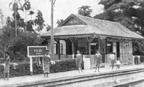
AT SAN SEN STATION, a typical country platform In Siam. The traffic is largely composed of local produce and agricultural goods. The principal export of the country and the main food of the Siamese people is rice.
By August 15, 1909, the railway had been opened to traffic as far as Pang Tong Phung to the north of Utaradit. A branch line had also been built for eighteen miles westward from Bandara to Sawankaloke, at the navigable limit of the Meb Yom River. Sawankaloke was formerly the site of a famous porcelain industry and to-
The final linking of Bangkok with Utaradit was an important event in the development of Siam, but the northern extension of the line constituted a great engineering triumph. North of Utaradit the Menom Plain ends, and the ground rises steeply to the mountain ranges.
It was from Utaradit that the caravans formerly started on their way through the mountains over the Kao Plung Pass to Phrae. This traffic was heavy and the pass was a busy highway. Wagons were supplemented by pack animals and carriers, following difficult trails through the wilder parts of the country. Transport charges were high, so that only valuable goods could be handled by the caravans. It was not a paying proposition to send cheap articles as the cost of transport was out of all proportion to their value.
Unfortunately the cheaper articles were in the greatest demand, and the authorities were soon brought to realize that a further extension of the railway was a necessity. The urgency of the matter was intensified by the congestion at Utaradit of goods brought up by rail at cheap rates from the south.
Work on the northern extension had been postponed in 1909, as the authorities had realized that the mountain section of the line would entail great difficulty in construction. With so pressing a need for advance, however, it was decided to resume work on the line. Construction was, therefore, pushed forward for twelve miles from Pang Tong Phung at the foot of the mountains to Meh Puak, on the northern slopes of the range and within easy reach of Phrae. This broken ridge divides the watersheds of the Menam Yai and Meh Yom Rivers, and every pass over the mountains was explored to determine the best route.
It was decided to use the Kao Plung Pass, and this section of line proved the most difficult in the whole of the constructional work on Siam’s railways. The line had to climb 600 ft in seventeen miles, and the rugged nature of the mountain-
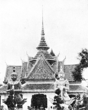
A PICTURESQUE FEATURE noted by the rail traveller in Siam is the number of Wats or temples where Buddha is worshipped. This photograph is of a well-
The railway traverses the Kao Plung Pass by a tunnel 1,188 ft in length and 230 ft below the wagon road over the pass. Because of trouble with water this tunnel had to be lined throughout with concrete. When building the railway between Utaradit and Meh Puak, a distance of twenty-
On January 26, 1912, the extension of the northern section of the line was begun, from Meh Puak through Lampoon to Chiengmai, 138 miles distant. The railway to Chiengmai was opened for through traffic in 1922.
Chiengmai, at the far north of Siam and 800 ft above the sea, is the second commercial city in the country, and its northern capital. It was founded in the eleventh century and served in turn for both Burmese and Siamese kings, and ruins of its ancient defences testify to a turbulent past.
Chierigmai is now the centre of Siam’s great trade in teak, and is a city with beautiful Buddhist temples, built on a broad and fertile plain served by the clear waters of the river Me Ping. Lofty wooded mountains form the horizon on all sides and its naturally beautiful setting is' enhanced by a picturesque population -
The Northern Line may be regarded as the most ambitious of Siam’s railways from the constructional point of view, but the greatest mileage lies to the south of Bangkok. The southern end of the Siamese railway system is linked with the lines of British Malaya leading to the great ports of Penang and Singapore. These lines are dealt with in the chapter “The Development of Malaya”. Travel on both railways is comfortable, with sleeping and restaurant car services. Passengers leave Singapore in the early morning, and after a journey of twenty-
The provision of this link with the Malay States has been greatly facilitated by the foresight of the Siamese Government in the choice of gauge, for their southern railway system. When the project was first discussed it was decided to build the track to the metre gauge to conform with the standards adopted by the railways of the Malay States and of Lower Burma. At the same time it was decreed that all railways built on the west side of the Menam River should be of the metre gauge, and that those on the eastern side should be of the standard 4 ft 8½-
Work on the Southern Siamese Railway was begun in 1899, and the line runs westward from Bangkok through Nakon Patom to the Meklong River, whence it turns south.
Nakon Patom, forty miles from Bangkok, is the capital of Nakon Chaisri, one of the most fertile provinces of Siam. One of the most striking places of interest in the town is the famous Patom Chedi, or sanctuary, the biggest monument of its kind in Siam. The top of the monument is 370 ft above the ground, and it is built on a square brick foundation mount, arranged in two terraces. Within the precincts of the sanctuary are a large number of Buddhist relics. According to popular belief, Buddha, who was born about 560 BC, once visited and rested at this place. The sanctuary was built in his memory.
After crossing the Meklong, the line follows the coast through Rajburi to Petchaburi, a distance of ninety-
Petchaburi is set in the midst of rice fields and, apart from the town itself with its interesting Siamese shops and houses, the district boasts of some remarkable caves used as Buddhist shrines.
Above the town also is a hill shrine with its many statues of Buddha, including one reclining figure some 150 ft long. On an adjoining hill is the palace built in 1860 for King Mongkut (Rama IV), which remains exactly as he left it. The furniture and pictures are English of the period and the Copeland and Garrett porcelain preserved there attracts connoisseurs from distant countries.
In September 1909 the line was pushed on south near the coast to Hua Hin, a distance of thirty-
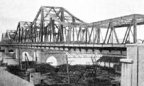
THE RAMA VI BRIDGE which crosses the Menam Chao Phya River at Bangkok. This structure provides a connecting link between the northern and southern lines of Siam.
From Hua Hin the railway continues down the coast to Chaiya, and from there to Tung Song Junction, with its branch line to Kan Tang on the Straits of Malacca. Leaving Tung Song, the line runs to Kao Choom Thong with its northern spur to Nakon Sritamaraj, about seven miles from the coast on the China Sea.
Nakon Sritamaraj is an ancient town situated about the centre of the Malay Peninsula. From it there runs a small river to the bay in which its first trading ships, the Chinese junks, found safe anchorage. The line from Kao Choom Thong runs through rice fields to Nakon and the town itself is set in the midst of them.
Despite the fact that most of the surounding country is flat and eminently suitable for the growing of rice, there are two great hills in the neighbourhood of Nakon. One of these, Kao Prong, rises to 4,500 ft; the other Kao Luong, is 5,800 ft high.
Nakon once dominated the Malay Peninsula, and contains many monuments of great historical interest. The shrine of Phra Buddha Si Hing contains a bronze image of Buddha which is reputed to be 1,000 years old. The great temple of Nakon, the Wat Mahatat, is a wonderful building with the upper part of the roof composed of solid gold plates. There is a gallery of 169 Buddhas, and by the entrance to the temple is an image of Buddha some sixteen feet high which also is said to be over ten centuries old. The Wat Mahatat contains also a museum and treasure house in which are stored priceless treasures of ancient Siamese art. South of Kao Choom Thong the railway runs through the town of Patalung to Naadyai Junction, at which point the line divides. The south-
The south-
A spur line also links Naadyai with Singora. This interesting town was founded about the middle of the nineteenth century by Chinese pirates. The bandits settled there, and after relinquishing piracy for trading and the cultivation of the soil, built a stout wall within which a flourishing town sprang up. Finally the Chinese leader of the community was recognized by the King of Siam and made Governor of the district.
A Link with China
The town, which is situated in beautiful surroundings at the entrance of a great inland sea, now does a good trade in rice and other products. It abounds in fine temples. The streets are paved with material taken from the old fortifications.
From Bangkok a line runs west to Petriu and Aranya Pradhesa, on the borders of French Indo-
The track on the Siamese Railways is well laid and is maintained in first-
It is not only the cattle that have a tendency to invade the precincts of the railway. The natives were quick to appreciate the value of the track as a highway, to be preferred to the primitive trails and cross-
Siam is particularly well-
The half-

THE PENANG-
You can read more on
and
and
“Travelling by Train in China”
on this website.