

The Development of Malaya
A Line That Brought Prosperity to the Jungle
RAILWAYS OF THE COMMONWEALTH -
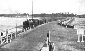
ACROSS THE JOHORE CAUSEWAY. A mail train of the Federated Malay Slates Railways on its journey from Singapore to Kuala Lumpur, a distance of 264¼ miles. The causeway is 60 ft wide, has a length of 3,465 ft, and connects the mainland with the island of Singapore.
THE lines of the Federated Malay States, Straits Settlements, and Johore State Railways have a special interest of their own. They have played a major part in the opening up of a valuable part of the British Empire which, not long ago, was the stronghold of pirates and warrior tribes. The modern history of the country is, in itself, a romance, due to the enterprise of British pioneers and scientists. British Malaya is not “a white man’s country”, but because of the enterprise, knowledge, and applied science of the white man it has become of vital importance in the history of modern transport.
British Malaya is a peninsula extending from Singapore, which is a degree and a quarter north of the equator, to the borders of Siam, nearly seven degrees north. With Sumatra on its west and Borneo on its east, it consists of a narrow tongue of land, 464 miles long, and nowhere more than 216 miles broad, forming the most southerly extremity of the continent of Asia. The surface is mountainous, the highest peak being Gunong Tahan, 7,186 ft; the longest rives is the Pahang, upwards of 330 miles in length. Except in the areas which have been mined or cultivated, a tropical forest covers the whole country, including the hills.
The country is divided up between the Crown Colony of the Straits Settlements, the Federated Malay States, and the Unfederated Malay States. There are four Straits Settlements -
Areas and populations are: Straits Settlements, 1,508 square miles, and 1,038,800; Federated Malay States, 27,506 square miles and 1,597,800; Unfederated Malay States, 23,486 square miles and 1,550,300. The total area -
Of the total population of over four millions, about 17,000 are Europeans. There are nearly two million Malays and one and three-
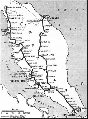
A SCALE MAP of the routes operated by the Federated Malay States Railways. There are 946 miles of metre gauge track open and also 121 miles of metre-
The name “Malay” means a flower called “the mistress of the night”. The Malay is highly spoken of by those who know him. He is suave, courteous, a sportsman, and a first-
British Malaya to-
Railway development in British Malaya is different from that in most countries, as the railway was made before the road. In nearly all other countries the jungle paths, trails, and rough roads existed for the railway to follow ; this was not so in Malaya. Once the coast was left, the tropical jungle was seldom crossed by a bridle-
To-
The total route mileage, at the time of writing, is 1,067, of which seventeen miles are double track. Of this mileage 121 miles of track in Johore are leased to the Federal Railway Administration. The railways run from Singapore, in the south, through Johore, Negri Sembilan, Selangor, Perak, Province Wellesley (included in Penang), Kedah, and Perlis to Padang Besar, on the Perlis-
Branch lines connect the main line with railway ports at Malacca, Port Dickson (Negri Sembilan), Port Swettenham (Selangor), Teluk Anson (Perak), and Port Weld (Perak). Steam ferry services are run between Prai (Province Wellesley) and Penang, and between Palekbang (Kelantan) and Kota Bharu. The harbours of Singapore and Penang are served by the main line. Thus all the important towns are connected by rail. The main line, the Port Swettenham branch, and the branch to Sultan Street (in Selangor) are laid with 80-
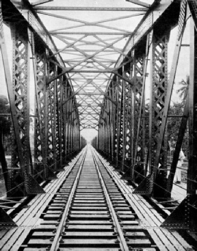
AN AVENUE OF STEEL. The Sungei Muda Bridge which carries the railway track across a river in the Unfederated State of Kudah on the north-
Forty-
The organization is vigorous; it distributes tourist literature throughout the world, and takes the opportunity on the occasion, for example, of a Chinese festival to issue posters in the Chinese language.
To induce ocean passengers to visit Malaya, the railway has arranged a first-
Books containing coupons for railway journeys for an aggregate distance of a thousand miles are obtainable at reduced prices, first-
The bulk of the goods traffic is, at present, merchandise, this item accounting for 507,122 of the 889,301 tons total of last available published traffic figures. Rubber was next with 219,677 tons; tin and tin-
So rapidly has the development of Malaya followed the pioneering of the railways and the demand for rubber, that the romantic ideas of the nineteenth century about this part of the Empire are out-
The temperament of the Malay is such that although he makes a satisfactory motor-
For a long time India was the eastern outpost of the railway, as the reputation of the peoples of the Malay Peninsula was such that the country did not seem to invite railway progress. Sailors dreaded the coast, which had a reputation for piracy rivalling that of the Barbary coast.
The relations of Great Britain with Malaya date from 1600, when a charter was granted to the East India Company. Penang was granted to Captain Francis Light in 1786 by the Sultan of Kedah, in consideration for protection against his enemies. Malacca was occupied by the British in 1795, afterwards handed to the Dutch, and later received in exchange. Singapore was founded by Sir Stamford Raffles in 1819. The British policy was one of non-
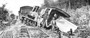
NATURAL OBSTACLES have constantly impeded the progress of the railway engineer in Malaya. Swamps, jungles, and wild beasts have had to be overcome. Here is a local train which has been derailed by collision with an elephant.
To-
The distance from Penang to Singapore is 488½ miles, and a morning and an evening express leaves each terminus. The journey takes about twenty-
Penang is a hilly island with one peak 2,500 ft high. The top of Penang Hill, on which are a hotel and a number of houses, is reached by a hill railway which starts about three miles from the jetty. This Penang Hills Railway is a cable incline railway about a mile and a quarter in length. The mean gradient is slightly less than 1 in 3, and the maximum is less than 1 in 2. The drive to the cable is through an electrically-
The cable is of sufficient strength to haul about fifteen times the load imposed when the car is carrying its full complement of passengers on the steepest section of the line; and two such cables are capable of lifting a modern express locomotive. The cars, with first-
Destruction by Rainfall
Construction presented a number of problems; the two most serious being the destructive force of the tropical rainfall and the intense heat. The downpour on the steep slopes of the hill is very heavy and this, combined with the heat, has broken and scoured the surface in a fantastic manner, only the prodigality of the vegetation preventing denudation of the steeper slopes.
On the upper reaches there are precipitous rock-
After crossing the 500 ft altitude mark, the track forms two loops, and at 550 ft the ascending and descending cars pass one another. Continuing upward the incline strikes through a yawning cutting having a maximum depth exceeding 60 ft. Emerging from this, the line runs on to a viaduct spanning a small gorge, the floor of which is more than 100 ft below the line, and then runs into the Middle Station, where the passengers change cars. This section lifts the passenger to a height of 1,160 ft, and the station affords magnificent views.
A short distance beyond the station the line skirts an immense inclined boulder, and then crosses one of the largest gorges traversed on the railway. Huge boulders are strewn over the floor of this gorge, and the selection of foundations for the supporting masonry piers among this mass of rocks involved diligent search. Cleaning the gorge, the line enters a cutting and emerges upon another viaduct, set on an easy curve. At the end of this is the loop for the passing cars; then comes another deep cutting, at the top of which some of the precipitous rocky slopes of the hill on either side of the line can be seen. The line continues, by cutting and viaduct alternately, to the toot of the spur of the hill. This is so abrupt and lofty that a tunnel had to be made on a gradient of 1 in 2.
After leaving the tunnel, which is lined with concrete, the line crosses another viaduct into the Upper Station, at an elevation of 2,390 ft. The view is excellent, a hundred miles of coastline being visible, and stretching from beyond Kedah Peak on the north to the south of Gunong Bubu, in Larut. Directly opposite rises Gunong Bintang on the boundaries of Upper Perak; while the whole of the eastern coast of the Island of Penang, with its harbour, lies almost immediately below.
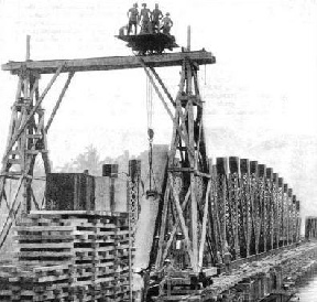
SPANNING THE RIVER. Building the Muda River Bridge in Kedah. The illustration shows the 250 ft. span under construction in October, 1914. Engineers are hoisting a section of steelwork into position.
The port on the mainland to which the railway ferry boat takes the passenger is Prai. The first twenty miles on the journey to Singapore are through Province Wellesley. To the east are seen the hills of the main range. The train proceeds through rice-
Near Parit Buntar the passenger glimpses in the distance to the south the twin peaks, 5,434 ft high, of Gunong Bubu (Mount Fishtrap). According to a Malay legend a giant used to let down Mount Fishtrap into the River Perak, and lift it up again full of fish. Another explanation of the name is that the shape of the mountain top renders it difficult to climb, and more difficult to leave, like a fishtrap.
The country here is served by the Krian irrigation scheme, a shallow reservoir of about ten square miles having been created. The last railway station in this rice area is Bukit Merah (Red Hill), which is nearly forty-
Taiping lies in the centre of the Larut plain, where tin has been mined for over half a century, and is also a centre for rubber estates. There is a branch railway to Port Weld, on the coast, this line being seven-
Beyond Taiping the main line leaves the mining plain, and climbs a pass in the hills towards Kuala Kangsar, seventy-
Elsewhere wild animals no longer interfere with the railways, but in the early days this was not always so. One train was going through a lonely stretch of country when the driver and fireman felt the engine give a violent jerk. The next instant they were flung to one side as the engine left the rails. They crawled out, to find that the engine had been derailed by a wild elephant which had stood in the track to dispute the right of way with the train. The elephant was dead, but it had caused serious damage to the train and the track.
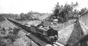 A COAL TRAIN on its journey from Batu Arang, a station near coalfields in the State of Selangor, to Singapore, a distance of some 265 miles.
The railway climbs to the top of the Bukit Gantang Pass through several tunnels, and where it emerges from one tunnel, and crosses a bridge spanning a gully, there is a good view of Gunong Pondok and the valley of the Perak River. The line runs along the foot of Gunong Pondok, a tree-
The commercial capital of Perak is Ipoh, 112½ miles, which is a big centre for the tin-
The line runs south from Ipoh, through Tapah Road, 145 miles, from where a branch line runs to the Perak River port of Teluk Anson. After Tapah Road the main line proceeds through jungle country to Tanjong Malim, 188½ miles, where the train leaves the forest, and crosses the Bernam River into the more open country of the State of Selangor.
This part of the railway journey to Kuala Lumpur, 242 miles, affords a variety of scenery -
Kuala Lumpur, where the express stops for several hours, is a garden city, and the administrative capital of British Malaya. In 1872, when it was a Chinese town with two streets, the local ruler paid cash down in the market place for the heads of his enemies.
Modern Workshops
The central workshops of the railway near Kuala Lumpur are equipped with modern machinery. Here the rolling-
Kuala Lumpur is linked with Port Swettenham by a line which is twenty-
The jetty is on screw piles, but the wharves rest on cylinders driven into the mud, the deepest going down to 132 ft. During construction and afterwards, the port was a very unhealthy spot, but soon governments in all parts of the tropics began to apply the knowledge scientists had gained of overcoming malaria. The Selangor Government put a bund round the site to keep out the sea-
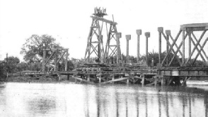 ERECTING THE GIRDERS of the large Langgar bridge in Kedah, January, 1915. The rail bridge has a single span, which measures 250 ft. Rivers and streams, often swollen by heavy tropical rains, constantly checked the railway’s advance. To simplify construction, the design of bridges throughout the Peninsula has been standardized as far as possible, the spans being usually of 100 or 150 ft. in length.
Returning to Kuala Lumpur and resuming the journey, the traveller proceeds through the pretty village of Kajang and on across the border into the State of Negri Sembilan. The name means Nine States, and is reminiscent of the old days before British Protection fused nine little Malay princedoms into one State. Seremban, headquarters of the Government, is 288 miles on the journey from Penang, and is a couple of hours’ journey from Kuala Lumpur. It is the junction for a branch line, twenty-
The next section of main line, some thirty miles -
Tampin is the junction for the line, twenty-
The City of Singapore
Gemas is important because from this town begins the East Coast railway which goes north for some 328 miles through the States of Pahang and Kelantan to Tumpat. The main line to Singapore proceeds through the State of Johore, and at Johore Bahru, 472½ miles, crosses the causeway to Singapore, the train crossing in the morning and steaming into the great port of Singapore, 488½ miles, which is on the south side of the island. On the morning express from Penang the restaurant car is taken off at Kuala Lumpur, and a parlour car and sleeping-
Singapore is a port of world importance. Its early history rests upon a tradition that some Malays settled there about 1360, but the settlers were killed some seven years later by invaders from Java. In 1703 it was offered by the Rajah of Johore as a present to Captain Hamilton, who declined it. In 1819 Sir Stamford Raffles signed a treaty by which the Johore plenipotentiaries ceded Singapore. For many years it was a source of supply to the Malay pirates, who preyed on vessels bound to or from the port; but with the advent of steam vessels, which did not depend on the wind, the pirates were checked. The development of the railways, giving communication with those of Siam, has added greatly to the strategic importance of Singapore. Bangkok, the capital of Siam, is within fifty hours of Singapore and within twenty-
The British Government realized from the beginning when it began to control Malaya that no other single force would exercise such a powerful and permanent steadying influence and lead to such rapid development as a system of railways. A constructional programme was therefore prepared with the purpose of building through the length of the country a continuous line, provided with lateral branch lines as occasion and traffic required.
This scheme was influenced by the fact that in Siam, a country friendly to the British development of Malaya, a scheme was in progress which would eventually take the railways to the borders of British Malaya.
But although the scheme was easy on paper there were many difficulties to be overcome. The Peninsula, covered with dense forest and jungle, was intersected by ranges of hills and mountains, between which the waterways make their winding ways east and west. As already stated, these rivers were the main arteries of native travel, and roads in the ordinary sense did not exist. Such tracks as were found proved to be ill-
So far as supplies of material and food were concerned the country was almost barren. When the railway pioneers began, the Malays had not become accustomed to peaceful conditions, and although they produced enough food for themselves they had none to spare, also their produce was not suitable to the support of white men in the tropics.
The food problem was a vital one, and monotony of diet was one of the problems that the pioneers had to solve. Driving roads through the jungle became a task in itself. The sodden, swampy ground was too treacherous to support the weight of a loaded vehicle until a corduroy road had been made, so that before anything could be done a rough highway had first to be made, and this took time. and was attended with many troublesome breakdowns. Except for timber, every ounce of material had to be imported from Great Britain, involving a sea journey of 8,000 miles.
Opening of the First Line
The first line, less than eight miles in length, was that already mentioned, from Fort Weld, on the west coast, to Taiping, which was opened on June 1, 1885, and assisted and stimulated the tin-
About the same time another line, farther south, from Klang, six miles up the river, was begun to Kuala Lumpur, also to develop the tin-
Railway construction went on steadily according to plan. The southern section crept northward from Kuala Lumpur to Kuala Kubu. About half-
By the end of 1901 fair progress had been made, a total of 244 miles of track having been built. A general manager and a chief engineer were appointed, but both died in harness within a few weeks of each other early in 1903, and a third Briton was appointed to the dual post of general manager and chief engineer. In 1903 the initial sections of the line were linked up, giving a network of 340 miles, and affording through connexion from Penang in the north to Seremban in Negri Sembilan.
When this first section of the trunk railway was completed, efforts were concentrated upon linking it with the base of Singapore, and an agreement was concluded with the Johore State Government. The construction of the Johore State Railway was taken in hand, beginning northward from Johore Bharu, which is on the mainland opposite the island of Singapore.
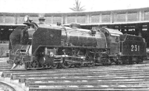
ONE OF THE LATEST TYPE of “Pacific” locomotive employed on the Federated Malay States Railways’ system. Express trains in British Malaya are hauled chiefly by two or three-
Moving northwards from this point, the surveyors experienced many adventures. The intention was to make the line as straight as possible along the route of 120 miles to the boundary of Negri Sembilan, and the surveyors, who set out in March, 1904, had to tramp for a hundred miles through virgin jungle. Once they were beyond Johore Bharu there were no means of communication, and progress was reduced to a crawl. All the supplies for the survey party had to be brought up from the base by carriers, as the route lay through the jungle for nearly the whole way.
When the constructional engineers set off to follow the line of stakes they were also handicapped by the lack of transport facilities. They made roads, and corduroyed them repeatedly, to support the heavier traffic between the camps. The heavy atmosphere in the depths of the forest was exhausting to the white men. The torrential rain hampered movement, and caused the rivers to overflow. Swamps, which could not be avoided but had to be crossed, swallowed spoil and ballast greedily.
The labour of cutting the timber to make the track through the jungle was heavy. The density of the jungle, and the speed with which vegetation grew, made it essential to cut a swathe 100 ft wide on either side of the single track. Most of the trees were not of soft wood, but were hard-
When the soil was laid bare, the railway builders found that the outlook was not attractive. The ground was streaked with rotten laterite, decayed granite and sandy clay, and was thoroughly saturated. When an embankment was raised the problem was to keep it in position, or safeguard it against obliteration by a landslide.
Abandoned Territory
So unstable was the soil that rain would set up an earth movement. The right of way was, therefore, made wider than usual to secure protection against disruption, and effective draining proved the best safeguard against landslips and subsidences in the embankment. Lallang grass was planted on the slopes, because the fibrous roots tend to bind the unstable earth and keep it in place.
The rivers and streams are numerous, and, after a heavy rain they change from insignificant waterways to menacing torrents. Culverts sufficed for the creeks, although they had to be introduced freely, averaging about four to the mile, but the larger streams had to be bridged. As far as possible bridges are standardized throughout the Peninsula with spans of 100 ft and 150 ft, so that the longer bridges are multiples of these two units. On the section from Johore Bharu to Seremban forty-
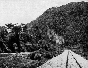
THE “SAKAI” CAUSEWAY, which carries the railway across a swamp between Merapoh and Gua Musang.
At formation level the road, although the track is of the metre gauge, was built to be adequate for the standard gauge of 4 ft 8½-
While this southern section was being built in the State of Johore, the northern section was being built southwards from Seremban to the inter-
The section from Seremban gave the surveyors much anxious thought, as the tail end of the mountain range which cuts across the Peninsula, presses somewhat closely upon the coast. The first plan was to carry the line to the border by way of Kuala Pilah, the headquarters of a district of Negri Sembilan. This would have involved the negotiation of the Bukit Putus Pass, 950 ft above the sea, and the climbing of 450 ft with a maximum gradient of 1 in 47½. Apart from the severity of the ruling gradient, heavy tunnelling and viaduct work would have been involved. Therefore, this route was abandoned.
The second location to be considered was through the Pabai Pass. This was more attractive than the first proposal, as the gradient could be kept down to 1 in 100, despite a vertical climb of 400 ft. But here again the heavy tunnel and viaduct work was prohibitive. It was evident that the project of carrying the line by way of Kuala Pilah, however desirable it might be, could not be achieved except at great expense. The idea was therefore abandoned, and the surveyors were given a freer hand.
There was no necessity to traverse the mountain country, which could be avoided by turning the line by way of Tampin and Batang Malaka. This alternative was carried out. In the neighbourhood of Tampin the surveyors were perplexed by the overlapping of the foothills of the mountain ranges, and by the broken character of the jungle fringing the Gemas River. Extensive surveying was necessary, because of the lack of means of communication. About 190 miles of trial lines had to be run by the surveyors, exclusive of the sixty miles previously carried through the Bukit Putus and Bukit Pabai passes, before the present route of sixty-
A Great Trunk Line Built
The survey of this section began towards the end of March, 1902, and was not completed until May, 1904; but the pathfinders gave a location with a ruling gradient of 1 in 100, and minimum curves of 1,910 ft radius, thus complying with those of the southern section in the State of Johore, although the curves had to be introduced somewhat freely to avoid heavy cutting and filling.
The railway builders began in July, 1903, and took the rails from Scremban Station towards the Malacca State boundary at Tampin, where a junction was effected with the branch to the port of Malacca. This branch line was opened for traffic in December, 1905. The main line was completed to Gemas and opened for traffic as far as this station; but not the short stretch of 1,147 yards to the boundary, beyond the station. This was held up, because the Johore State Government wished the railway to be opened through its territory in complete form, instead of section by section.
For this reason, the first seventy miles of railway out of Johore Bharu, although ready for traffic by August, 1908, were not brought into immediate service. The section to the Gemas River was pushed forward with all speed. On July 1, 1909, the whole of the railway through Johore was brought into service, and through communication was thus established with Penang.
By this date the whole Peninsula, with the exception of the less accessible State of Pahang to the north, was provided with a railway backbone. The jungle was subdued. The country was provided with a great trunk line, as well as a number of short lines running to the coast from important centres, and tapping all promising and productive zones.
Although Johore Bharu was the southern terminus of the railway, it was on the mainland, and not on the island of Singapore. To make contact with the great port without transhipment, a freight-
This system had obvious disadvantages, and the work of building a causeway to carry the railway and a road was put in hand.
As early as 1904, it was suggested that the straits should be bridged, but this, and other suggestions, had to be put aside for years, and it was finally decided that a rubble causeway should be substituted for a bridge. The official inauguration of the causeway works took place in April, 1920, when the Governor deposited two barge loads of rubble in the centre of the straits. The ceremonial opening was performed in June, 1924, by the Governor in the presence of the Sultan of Johore and the rulers of the Federated Malay States.
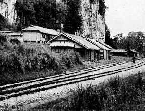
THE STATION at Gua Musang.
The causeway is 60 ft wide at the top, and carries two tracks of railway and a 26 ft roadway. The total length is 3,465 ft. The greatest depth crossing the strait is 77 ft, the average depth of water at low tide being 47 ft. Provision was made at the Johore end of the causeway for the passage of small local craft by the provision of a lock, 510 ft long from end to end. The lock is provided with a double set of gates spaced 170 ft. apart, with a width inside the gates of 45 ft., and outside of 32 ft. This lock has been crossed by a Scherzer roller bridge with three girders. The bridge is 57 ft total width, and carries two lines of railway, and a clear roadway of 24 ft 6-
A Link with Siam
The work of providing the trunk line with feeders was pursued during the construction of the main line and afterwards. The fifteen miles branch from Ipoh, in Perak, to Tronoh, which serves the Kinta Valley tin-
Once the main line from Prai to Johore Bharu was completed, the railway builders turned their attention to the northern part of the Peninsula to carry out the project of linking up with the railways of Siam. The line from Prai was picked up at Bukit Mertajam, which is about seven miles from the port, and was advanced northward into the State of Kedah, reaching the capital, Alor Star, in 1915 -
Before the rails met, the alert authorities had visualized the effect the junction would have on sea-
The work included the construction of a reinforced concrete jetty, 1,100 ft in length, at the mouth of the river; the continuation upstream of the existing wharf for 600 ft, and beyond a coal wharf 900 ft long -
Enlarging a Modern Port
As little was known of the site before the coming of the railway, exhaustive surveys and borings were essential. The river-
It was decided to use the sand as the foundations for the wharves and jetty, and a specially massive design of ferro-
The coal wharf and widening, extending upstream for 1,500 ft, follow the concrete block wall design. This wall is protected against the scouring action of the river by an apron of rubble extending from the toe of the wall for a distance of about 35 ft.
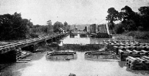 WELL SINKING and the construction of girders across the Korok River, in Kedah, during the building of a railway bridge. To the left of the picture can be seen a temporary service structure for the conveyance of material and engineering equipment.
The widening and deepening of the main channel and approaches was the largest individual item of the enterprise. This work entailed the removal, by dredging, of 2,250,000 cubic yards of material from the river-
Special arrangements were adopted for draining this water-
Thus the railway conquest of the Federated Malay States was carried out along the western coast. This side of the Peninsula is the more densely settled and is more easily accessible.
The eastern state of Pahang, however, differs markedly, the chain of mountains cutting it off from its neighbours. Because of this and the fact that in building a railway in an undeveloped country the first lines are built where they are most urgently required and where the traffic will justify them, the east coast was left until the western seaboard railway system was adequate.
When this was so the railway engineers turned their attention to providing the east side of the country with lines to facilitate settlement, and to provide a link with the interior.
At the Frontier
Work began in the north-
The construction of the East Coast line cutting diagonally across the Peninsula from Gemas was difficult, because of the obstacle of the mountains. The pathfinders tried to obtain a line that would conform in gradient and curves with the lines already built, but the quest was tantalizing. In accordance with general practice, the surveyors endeavoured to turn the courses of the streams to account. They followed one river here, crossed another there, and picked up another elsewhere, as far as the watershed, and then followed a similar practice down the opposite slope. In this manner the surveyors brought back proposed locations conforming to the general scheme of the railways -
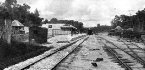
BATU ARANG STATION, on a branch line between Kuala Lumpur and Penang, lies some twenty-
In the search for an easy gradient, the first trial line was run from Gemas Station up the valleys of the Muar and Serting rivers for thirty-
Further consideration of the surveys induced the chief resident engineer, in charge of work in the field, to try to find a third route. He instructed the surveyors to explore the lie of the land farther to the east, with the result that a third and superior line was adopted.
This abandons the original alinement altogether upon leaving Gemas Station, bearing more to the north, and crossing the Muar River near the sixth mile-
The surveyors found the country sparsely populated. Two miles from Gemas they discovered a small native village, or kampong, of about forty people, engaged in the breeding of buffaloes, the cultivation of rice, and the collection of jungle produce which they exported by means of the river.
Thrusting the Line Northwards
Small settlements were discovered at intervals up to Rompin, where the surveyors found a Malay village of seventy inhabitants. Throughout the next few miles only a few isolated huts were seen, these being occupied by Sakais, the aborigines, who eke out a living by cultivating maize and yams. Bahau was only a small Malay kampong; but from a point two miles beyond, to Kuala Pilah, the country was fairly well populated by Malays. One stretch of country, thirty-
From Temerloh, the next stage northward was to Kuala Tembeling, 117 miles. This section is roughly parallel with the Pahang River, which flows into the China Sea, and the line was set back so that a fairly straight alinement, avoiding the windings of the river, was presented.
The country traversed was practically uninhabited virgin jungle. There were settlements on the banks of the river, the highway of the natives, but these did not penetrate the forest to any distance. This population became more scanty as the railway pushed northwards, the villages being very small and infrequent, and peopled by natives of an inferior type. There was no sign of any industrial activity along this length of the line.
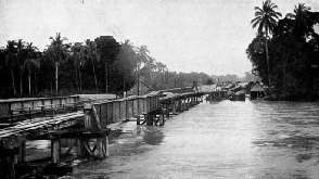 ENDANGERING THE WORK IN PROGRESS. The Muda River in Kedah overflowing its banks, threatening a bridge-
By keeping near to the river the engineers were able to round the Tahan Mountains on the east, and obtained not only a much shorter road than would have ensued had the western turning of the mountain been adopted, but also one which was considerably cheaper and more economical to lay. The section north from Tembeling to Kuala Lipis, 141 miles, was opened in 1917. This part of the line followed the river and involved at one point the construction of a retaining wall 400 ft in length and a viaduct of three brick arches. To the north, in Kelantan, thirty-
Soon after the war the resumption of work was hampered by trade depression, and it was not until 1921 that a further stretch of five miles of track was added to the southern section, which was creeping up northward from Kuala Lipis, the new railhead being at Padang Tungku.
The engineers working southward reached the Kelantan River, thirty-
It was not until September, 1931, that the East Coast Line was opened to traffic, the last section to be completed being that between Gua Musang (200 miles from Gemas) and Kuala Gris, in Kelantan. A through service was begun, an express leaving Tumpat, the northern terminus, every Thursday morning, with day and night accommodation, and reaching Singapore the next morning, the journey occupying twenty and a half hours. The express in the reverse direction leaves Singapore on Sunday evening, and arrives at Tumpat on Monday afternoon. Mixed trains (passengers and goods) run in addition.
£70,000 for Repairs
At the end of the year, in December, the Peel Bridge at Kemubu, 235½ miles from Gemas, collapsed because of the abnormal rise of the river. The bridge consisted of two main spans of 250 ft each and a land span of 150 ft. The river, after having begun to rise at the rate of 10-
Apart from the work of rebuilding the bridge, the line was badly damaged at many points, and the cost of reconstruction was more than £70,000.
The engineers and administrative officers had a busy Christmas. The line was closed for only a few days, as it was imperative to get food through to the regions devastated by the floods. A train was sent out on December 22 from Kuala Lipis, in Pahang, under orders to go north as far as possible. This was forced back by the floods. A railway tug and a lighter were then sent from Kota Bahru up the swollen River Kelantan to Krai with food for the suffering natives. By Boxing Day the railway officials at Kuala Lipis had got into operation a temporary train service to Gua Masang, while their colleagues more than 130 miles to the north at Krai, in Kelantan, were stretching out a temporary service to the south. Some very fine work was done to relieve distress during this period of flood. It was not until months had passed, in April, 1932, that the East Coast Line was reopened throughout its entire length.
While the East Coast Line at the northern end of the Peninsula was being repaired and consolidated in 1932, important developments were being completed at the southern end, on the island of Singapore, this work being the consummation of a programme which had been in hand for some three years.
When in June, 1932, the Governor of the Straits Settlements, Sir Cecil Clementi, opened the new terminal station at Singapore, he said that he stood at the end of a chain of railways which would one day form a continuous line of permanent way from the Strait of Dover through Europe, Turkey, Mesopotamia, Persia, Baluchistan, India, Assam, Burma, Siam and Malaya to where he stood. The missing links in the chain are from Prachuah in Siam to Ye, the Siamese end of the Burma system, between Burma and Assam, between Baluchistan and Basra (Iraq), between Mosul (Iraq) and Aleppo (Syria), and the ferry across the Bosphorous, between Asiatic and European Turkey.
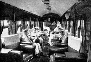
COMFORT IN THE TROPICS. One of the buffet parlour cars, complete with arm-
You can read more on
and
and
“Travelling by Train in China”
on this website.