
A Link With the Mediterranean
Remarkable Engineering in Southern Europe

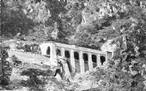
THE BEVERA VIADUCT, near the town of Breil is this viaduct of unusual construction. It consists of four masonry arches, each of 26 ft span, and of two steel girder spans, each 150 ft long. These steel girders are, as can be seen, supported in the centre by a single masonry arch set at right angles to the axis of the bridge, and crossing the gorge.
ONE of the most beautiful regions in Europe is the territory that is bounded on one side by the Franco-
The northern part of this region, above the line from Cuneo to Genoa, is a highly industrialized part of Italy, and forms the important district of Piedmont, containing the city of Turin, which lies on one of the great highways of Europe. The necessity of improving direct connexion between this part of Italy and the Mediterranean had long been felt. As far back as 1900 the railway line had been completed from Cuneo to the French frontier immediately beyond San Dalmazzo di Tenda, a distance of fifty-
For many years political considerations prevented the completion of the line. Although this French district would have considerably benefited by the proposed Italian line to Ventimiglia, the French Government was reluctant to entertain the project unless the new line was counterbalanced by a purely French railway line to Nice from Breil, at the southern frontier of the wedge. An agreement was eventually reached between the French Government and the PLM Railway Company on the one hand, and the Italian Government on the other, and the work on the Breil-
Both railway lines rank among the finest railway engineering achievements in Europe. They are remarkable for their many technical features as well as for the natural beauties of the districts traversed. The two railways will be described separately.
The Italian line from Cuneo to Ventimiglia will be described first. The total length is sixty-

THE STATION OF PIENA on the Cuneo-
The gradients on this section are mostly 1 in 40, The highest point in the open is reached at the station of Limone, at an altitude of 3,288 ft above sea-
The clay, through heavy infiltration of water, was in an almost liquid state, and work was completely held up by the clay-
“Valley of Wonders”
On leaving this tunnel the line enters the Roia Valley. The ground encountered from this point as far as the French frontier consisted of Triassic and Permian soil, with interposed Jurassic and Devonian formations. On this section also is found an almost continuous sequence of noteworthy constructional works. Particularly interesting are the viaduct over the Roia, which has five arches, each of 50 ft span, and that over the Tenda, which has twelve arches of 66 ft and one of 40 ft span. Among the many tunnels there are the Branego Tunnel, in the shape of a horseshoe, 1,436 yards in length; the Cagnolina Tunnel, which is loop-
Shortly after the Bosseglia Tunnel the line reaches San Dalmazzo di Tenda, the last station before the French frontier. San Dalmazzo di Tenda, though a small village, boasts a large station covering many acres. It is one of the principal stations of the line and handles a considerable amount of traffic. It is important as the centre of a series of electric power plants which are driven by water conveyed from storage basins of a capacity of about 2,500 million gallons through pipe-

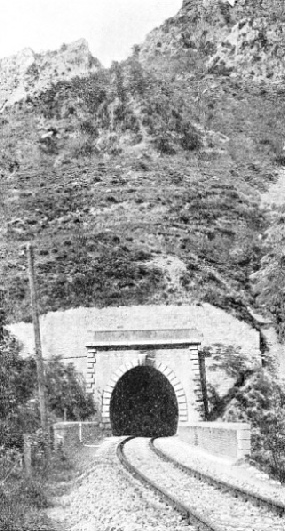
THE ENTRANCE to the Scarassoni Tunnel on the Nice-
The line leaves French territory near the station of Piena, and continues in the Roia Valley, which at certain points is so narrow that the steep mountain slopes almost seem to meet. Tunnels and viaducts alternate almost uninterruptedly. The most important tunnels are those near Aerie (900 yards) and near Bocche (930 yards).
Among the viaducts is the fine structure over the Roia, which has five arches, each of 46 ft span; the Lamberta Viaduct, with five arches each of 46 ft span and two of 33 ft; the Bocche Viaduct, with three central arches each of 70 ft span and two of 33 ft; the Allaveni Viaduct, 350 ft long and composed of ten arches; and the Bevera Bridge, having four concrete arches each of 66 ft span. This last-
The total number of tunnels on the line is sixty, and their total length is twenty-
At the present time the line is in course of electrification on the three-
Not less interesting is the connecting French section from Nice to Breil, and to the Italian frontier near San Dalmazzo di Tenda. The length of the line is thirty-

THE SCARASSONI VIADUCT, on the French line between Nice and the Italian frontier near the station of San Dalmazzo. This route was laid by the Paris, Lyons and Mediterranean Railway. The line is single track except in three long tunnels, where it is double track.
On leaving the fine station at Nice, which has been enlarged to provide additional lines for the new railway, the track runs inwards for about a mile, and then crosses the River Paillon. It follows the river valley for about thirteen miles over mountainous ground, with gradients up to i in 45, which carry the line to an altitude of 1,300 ft. All along this stretch a large number of tunnels and viaducts had to be constructed to negotiate the difficult and treacherous mountain slopes.
It became necessary to strengthen the permanent way from below by supporting walls and structures and to protect it by massive retaining walls against the danger of landslides. The Erbossiera River is crossed by a fine viaduct having a centre span of 120 ft, with supporting arches and four lateral arches of 30 ft span. The rails are here laid 150 ft above the valley. This viaduct leads into a tunnel 690 yards long, from which the line emerges into the wide and deep valley containing the beautifully situated village of L’Escarene.

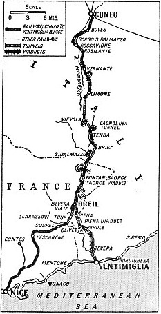
THE ITALIAN LINE from Cuneo to Ventimiglia has a length of sixty-
This valley is crossed by a viaduct of eleven arches, each of 49 ft span; the height over the valley is 135 ft. The line now leaves the Paillon River and describes a semicircle on a gradient of 1 in 60 through a short tunnel before reaching the station of Touet de l’Escarene. Immediately beyond the station it enters the tunnel bored through the Col de Brans. This tunnel, which has a length of 3 miles 1,205 yards, is one of the longest in France. Over the first half the line rises at a gradient of 1 in 500 to the highest point (1,368 ft), from which it descends at 1 in 110.
The construction of the Col de Brans Tunnel was very difficult because of the calcium sulphate of which the rock was composed. This substance decomposes ordinary mortar, and special mixtures had to be used. Another peculiar property of calcium sulphate is that it dissolves, though slowly, in water, with the result that caverns are formed in the ground. Furthermore, by the absorption of water, the calcium sulphate turns into gypsum and swells considerably. Tremendous pressures were exerted which hampered the keeping up of the advance headings. Notwithstanding every precaution these repeatedly collapsed.
As mentioned above, work was begun in 1910, and by the time war broke out in 1914 part of the tunnel had been completed. From 1915 until the resumption of the work after the war the tunnel remained exposed to the great pressures of the swelling soil. When work was resumed the tunnel was thoroughly inspected and it was found that at several points settlements had occurred and other damage had been done. This fact provided the engineers with valuable information and enabled them to take effective measures for preventing further trouble of a like nature. Mortar was made with a form of cement which was chemically not affected by the action of the calcium sulphate. It was found also that the dissolution of calcium sulphate in water had caused the formation of hollow spaces behind the lining. To prevent a recurrence of this trouble, all watercourses were diverted into specially constructed canals in the tunnel or into outlets in the mountain slopes.
After emerging from the Col de Brans Tunnel the line enters the picturesque valley of the Bevera, in the middle of which lies the town of Sospel. On leaving the valley the river is crossed by a viaduct of unusual construction. It consists of four masonry arches, each of 26 ft span, and of two steel girder spans, each 150 ft long, which are supported in the centre by a single masonry arch set at right angles to the axis of the bridge.

CAGNOLINA TUNNEL, between San Dalmazzo and Cuneo. This tunnel is loop-
Considerations of cost were mainly responsible for this construction. As all the material had to be carried by road it would have been an expensive matter to construct a single girder bridge of about 300 ft, whereas the construction of the supporting arch permitted the use of two comparatively light spans, each half this length.
Shortly beyond the Bevera Viaduct the line crosses another viaduct of seven arches, each of 39 ft. It now enters a tunnel of 2 miles 730 yards bored through Monte Graziani, which is in Italy. The tunnel has the probably unique feature in that both its mouths are in the territory of one country, France, whereas the mountain itself is in the territory of another country, Italy.
On leaving the tunnel the line enters the Roia Valley. An exceptionally fine view is unfolded. The Roia Valley lies deep below, with the Ventimiglia-
At Breil. a commodious station has been laid out to cope with the traffic. The station building is a large structure and contains ample halls for the French and Italian customs examination. On leaving Breil the line rises on a gradient of 1 in 40 through the narrow valley of the Roia as far as the Italian frontier.
Winter Sports on Riviera
Near the village of Saorge the valley is crossed by a graceful single-
The French line has been constructed by the PLM Company. It is single-
The opening of the two lines in 1928 has brought about the development of tourist traffic in those parts of France and Italy which were previously almost unknown to the hundreds of thousands who annually seek health and repose on the shores of the Mediterranean, Europe’s playground. Many resorts have sprung up. Where up to a few years ago only picturesque village inns provided accommodation for the rare tourists, to-
Well-

VIADUCTS AND TUNNELS on the Ventimiglia-
You can read more on
“Modern Construction in Italy”, and
on this website.