

Engineering in New Zealand - 2
Outstanding Achievements in the South Island
RAILWAYS OF THE COMMONWEALTH -
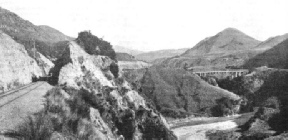
BROKEN RIVER VIADUCT. The length of this structure is 441 ft, and the track is carried 130 ft above the water. It is on the Trans-
NO less interesting than the railways of the North Island of New Zealand are those in the South Island. The mountain backbone of the South Island reaches considerably higher altitudes than any of the mountain ranges in the North Island. As compared with the latter’s highest peak -
For many years of railway history in the South Island this mountain chain proved an insuperable obstacle to railway communication. The main railway system, connecting the cities of Christchurch, Dunedin, and Invercargill, along the plains that fringe the sea down the east coast of the island, was completely cut off from the smaller west coast system, serving Westport, Greymouth, and Hokitika. But the mountain chain was finally pierced, and the two systems were linked up. In the Otira Tunnel, five and a quarter miles in length. New Zealand is proud to possess the longest railway tunnel in the British Empire, beating the Connaught Tunnel of the Canadian Pacific Railway, in the Rockies, by a little over a quarter of a mile. The tunnel was completed and opened in 1923, and will be referred to in more detail later on this page
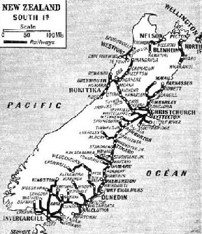
A casual reference to the map might lead the observer to the conclusion that the obvious connexion between the North and South Islands of New Zealand is across the narrow width of the Cook Strait, from Wellington across to Picton. A steamer service is certainly maintained across this often rough stretch of water, and a railway is found on the south side of the strait. But it travels only as far as Wharanui, down the east coast. Then comes a stretch of very difficult country, from the engineering point of view, where the Kaikoura ranges strike out to the coast. This region also is so sparsely populated as to offer little inducement for railway building.
At present, therefore, there is a gap of eighty-
A dramatic introduction to the South Island is obtained on this voyage. The rocky gates through which the steamer passes into Lyttelton Harbour are really the opening of an ancient volcanic crater, and the bills that encircle the harbour, with their ramparts of rock at various points dropping sheer down to the water, are largely composed of lava. It is through a precipitous rhyolite lava range that the train makes its Way by tunnel out of Lyttelton. The tunnel, 2,860 yards in length, was the longest in the Dominion until the opening of Otira Tunnel. Yet Lyttelton Tunnel formed a part of the first railway to be laid in New Zealand.
THE FIRST RAILWAY in New Zealand was opened in December, 1863. The line, nearly three miles in length, ran from Christchurch towards Lyttelton. To-
Lyttelton Tunnel, indeed, was a tremendous problem. The settlement was less than twenty years old when the railway was decided on in the ‘sixties, and the tunnel alone cost £195,000.
Each province in those days had its own parliament and its own system of finances; and it fell to the Canterbury Provincial Government to find the money for the scheme. The engineer and chief surveyor of the province was entrusted with the engineering of the line -
This first railway in New Zealand had a gauge of 5 ft 3-
It was in December, 1863, that the first railway track in New Zealand came into use. This was a line just under three miles long from Christchurch, in the direction of Lyttelton. The work of boring Lyttelton Tunnel held up the next three and a half miles, which were not opened until four years later. By that time an extension southwards from Christchurch, forming a part of the present main line to Dunedin, had come into use. But again one of Nature’s obstacles lay athwart the path of the engineers, and held up further extension for nearly six years. This was the width of the Rakaia River, which for more than a mile had to be bridged.
The history of railway construction in the South Island is largely bound up with the crossing of rivers. Sweeping across the eastern plains from the western mountain chain, these great streams, fed by water from glaciers, had to be spanned one by one. It was width rather than depth that troubled the engineers in making their structures. Rakaia Viaduct, the longest in the whole of New Zealand, has a total length of 5,966 yards. By June, 1873. it had been brought into use, and construction then proceeded more rapidly.

A “K” CLASS LOCOMOTIVE. Thirty of these powerful 4-
Meanwhile work had been proceeding much farther to the south. A railway was opened in February, 1867, from Invercargill to Bluff -
But the bulk of the constructional work on the main line was carried out between the years 1875 and 1878. September, 1878, saw the completion of the last link between Christchurch and Dunedin -
Of other river crossings, the biggest, after the Rakaia Viaduct, is the bridge across the Waitaki River, near Oamaru, 3,733 ft long. The two arms of the Rangitaka River also required some extensive bridging, with one viaduct 1,978 ft and the other 1,016 ft long.
For the first 130 miles out of Christchurch the line is level. One by one the waters of the great rivers are crossed -
Beyond the broad Rangitaka comes the South Canterbury country, which extends for sixty miles southwards to the Waitaki River, separating it from Otago Province. The plain gives place to hilly country coming down to the sea, and from Timaru onwards the railway hugs the coast as far as Dunedin, whence a sinuous course, farther inland, is followed to Invercargill and Bluff.
During its progress, the railway has thrown off many branches inland, up the rivers towards the mountains. It was one of these, in the valley of the Waimakariki River from Rolleston Junction, that was finally carried into the heart of the mountains at Arthur’s Pass, to pierce the ridge and link up with the lines on the western seaboard.
The Otira Tunnel itself was, of course, the most costly and difficult part of the undertaking. In length it is five and a quarter miles, and it is of horseshoe shape in its cross-
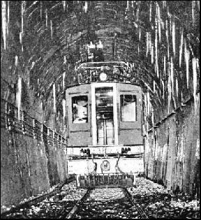
THE LONGEST RAILWAY TUNNEL in the British Empire is the Otira Tunnel in the South Island of New Zealand. This tunnel is about five and a quarter miles long and is 17 ft high and 15 ft wide. The tunnel is dead straight, but the single line through it has a gradient of 1 in 33. Because of ventilation difficulties the track through the tunnel has been electrified.
Because of the fact that the tunnel has only a single track, and exceptional steepness of gradient, it was apparent that considerable difficulties in ventilation would be experienced if any attempt were made to use steam traction through it. Overhead electrification has therefore been installed. At both entrances the steam locomotives are detached from the trains, and electric locomotives substituted. Electric light signalling is also used on the tunnel section. Including the connecting lines and the electrification, which extends over a distance of nine miles in all, the railway administration spent the large sum of £1,500,000 on this scheme; but the vast improvement in the South Island communications that it has effected has doubtless justified the expenditure.
Some costly engineering work had also to be carried out on the approaches to the tunnel, especially in the mountain gorge through which the railway is carried rapidly down the short distance from Otira to the west coast. In addition to the main tunnel there are seventeen other tunnels, and three big steel viaducts, one of which carries the line 236 ft above the ravine that it spans. At Stillwater Junction the tunnel route joins the previously existing railway from Seddonville and Westport to Greymouth and Ross, and in a few miles from Stillwater the passenger is at Greymouth.
Northwards from Christchurch the railway has thrown out a line as far as Parnassus, which completes a main route 471 miles in length, down the east side of the island from Parnassus in the north to Bluff in the extreme south. From Parnassus there exists the gap in communication, previously mentioned, of eighty-
Powerful Locomotives
In the locomotive department New Zealand has achieved some striking developments on a gauge as narrow as 3 ft 6-
The “K’s” are the logical development of the previous “Ab” class “Pacifics”, which have 17-
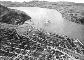
OTAGO HARBOUR, adjoining the town of Dunedin. This photograph shows the fine sweep of rails running to the harbour. The main line between Dunedin and Christchurch is connected with the railways on the western side of the island by the mountain line through the Otira Tunnel.
The fastest running in the South Island is between Christchurch and Dunedin, a journey 226 miles in length and comparatively easy from the working point of view, as 120 miles of the course are level. But the time of seven hours forty-
Acceleration of the existing train services should prove a matter of no difficulty when the railway administration regards this as economically justifiable, Such speeding-
To-
More than 2,000 Bridges
There are in all no fewer than 2,472 bridges in New Zealand, comprising 10,704 spans with a total length of 354,440 ft, equivalent to 48.2 miles. Twenty-
The New Zealand Government Railways own about 650 locomotives, 1,500 coaches and over 25,000 freight vehicles. The latest types of locomotive, such as the “Ab” 4-
From modest beginnings, comparatively late in the world’s railway history, the railways of New Zealand have attained a position of first-
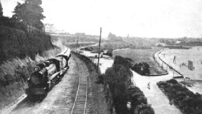
THE CHRISTCHURCH-
You can read more on
“Engineering in New Zealand -
and
and
on this website.
You can read more on
“The British Empire’s Longest Tunnel”
in Wonders of World Engineering.