
© Railway Wonders of the World 2012-


Nigeria & Sierra Leone
The Influence of the Railway in West Africa
RAILWAYS OF THE COMMONWEALTH -
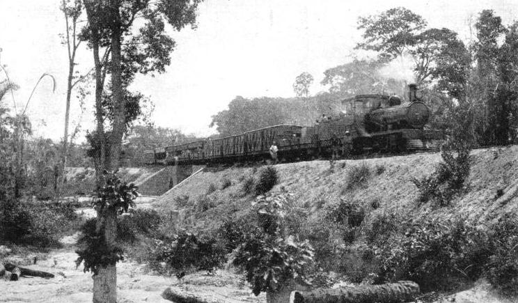
A LOCAL TRAIN passing over the completed Pimmi Bridge on the extension north of Lagos. This bridge is one of the many smaller bridges which are a prominent feature of the line.
IT is only in the last few decades that the British West African colonies and protectorates have been opened up by means of railways. An example of this civilizing process is furnished by the Gold Coast railway. The other West African colonies are Gambia, Sierra Leone, and Nigeria. Each of these administers, in addition, an extensive protectorate.
Gambia, the most westerly of the four, is a narrow strip of territory on either side of the River Gambia, extending eastwards from its mouth, and surrounded by the French colony of Senegal. The colony comprises the Island of St. Mary with an area of four square miles. Various other islands and riparian divisions make up the protectorate, whose area is 4,130 square miles. Since, however, Gambia has no railway, transport being mainly by water, it does not concern the railway enthusiast.
To the south of Gambia, beyond French and Portuguese territory, extend the colony and protectorate of Sierra Leone. The Negro republic of Liberia and the French Ivory Coast separate Sierra Leone from the Gold Coast. Farther into the Gulf of Guinea, beyond French Togo and Dahomey, is Nigeria.
Nigeria owes its name to the Niger River, which rises in the Futa Jallon Mountains, near the borders of Sierra Leone, flows in a horseshoe curve through French West Africa, and then runs south into the Gulf of Guinea, after a course of about 2,600 miles. Its principal tributary is the Benue River, which joins it at Lokoja, about 340 miles from the sea. Other tributaries are the Rima (or Sokoto) and the Kaduna.
The colony and protectorate are bounded on the west and north by French territory, on the north-
Nigeria is more densely populated than any other part of Africa, except the area watered by the Nile. On January 1, 1914, the territory was divided for administrative purposes into the colony of Nigeria and the protectorate, subdivided into the Northern and Southern Provinces. The colony has an area of 1,381 square miles and a population of 325,020 (1931 census). The eleven Northern Provinces have an area of 281,778 square miles and a population of 11,434,924. The corresponding figures for the eleven Southern Provinces are 89,515 and 8,168,227. Including the mandated territory of the Cameroons, treated administratively as one of the Southern Provinces, the total area is 372,674 square miles, or more than three times that of the British Isles. The population is nearly 20,000,000, the non-
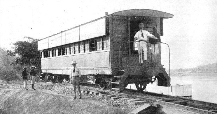
THE OFFICIAL TRIAL of a slip-
There are four main zones of country. First, there is a belt of swamp and mangrove forest which follows the coast line and is from ten to sixty miles wide. It includes the delta of the Niger, and is intersected by many rivers and creeks. Next comes a belt of dense tropical forest from fifty to a hundred miles wide, intersected by streams, and rich in oil palms. Then follows a belt of more open country, which rises to the fourth zone, a vast undulating plateau, of an average height of 2,000 ft, with occasional hills of granite and sandstone, and some heights of over 6,000 ft. The southern side of this region is covered by thin forest, but towards the north the country becomes more open until the sandy tracts that border the Sahara Desert are reached.
In the north of the Cameroons Province begins the Central African plateau with an average altitude of 4,000 ft, and in the south, near the sea, is the volcanic Cameroons Mountain, 13,350 ft high, which was active as recently as 1922.
The coast of Nigeria first became known to Europe towards the end of the fifteenth century, when the Portuguese were establishing the Cape of Good Hope route to India. During the next century several English merchant adventurers visited the coast. In 1590 James Welsh returned to London with a cargo of “589 sacks of pepper, 150 elephants’ teeth and 32 barrels of Oil of Palm trees”. By the end of the sixteenth century Benin had become a trading centre for English, Dutch, and Portuguese merchants.
Bridging the Niger
In the early years of the last century Great Britain decided to suppress the slave trade, of which the island of Lagos was the centre on this part of the coast. By 1850 Lagos, under its usurping king, Kosoko, had the reputation of being the biggest slave depot on the coast. In December, 1851, a British naval force of 400 officers and ratings landed and drove Kosoko out and restored the exiled king, Akitoye. This king’s son, finding himself unable to stop the traffic in slaves, ceded Lagos to Great Britain in 1861. Lagos and its dependent territory became a British colony in 1862. Four years later the colony became part of the West African Settlements under the Governor-
East of Lagos, the various British firms trading on the River Niger amalgamated, and in 1887 a Charter was granted to the amalgamation which became the Royal Niger Company Chartered and Limited. In January, 1900, the company's territories became the property of the Crown, with Colonel (afterwards Lord) Lugard, one of the makers of British West Africa, as the first High Commissioner.
Nigeria was constituted in 1914 as stated above. At that time two areas each having a separate and disconnected railway system, based on Lagos in the West and on Port Harcourt in the East, were united.
At the present day the Nigerian Government Railway has 1,772 miles of 3 ft 6-
The first railway in Nigeria was that from Lagos, and was begun in 1893, although the first section to Ibadan was not opened until 1901. The main line section of this Western Line runs from Lagos (Iddo and Apapa stations) to N’guru, a distance of 847 miles, passing the important towns of Abeokuta (served by Lafenwa Station on the main line -
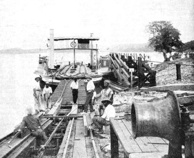
ANOTHER VIEW of the slipway, together with the train-
For a long while the Niger was an obstacle to the railway, but two bridges, finally completed in 1916, were built, totalling 1,795 ft in length.
On the Western Line there are four branch lines. These are: (a) From Ifo Junction to Ilaro and Idogo, twenty-
The Western Line rises from sea-
A well-
Apart from this “Boat Express”, a regular passenger service with dining and sleeping-
Lagos, the capital of the colony, has a population of over 126,000 Africans and some 1,300 Europeans. The township includes the islands of Lagos and Iddo, Ebute Metta and Apapa on the mainland, and a part of the land lying between the lagoon and the sea. Lagos is the terminal port of the Western Line, which was formerly known as the Lagos Railway. The two Lagos termini are Apapa Station, on the mainland opposite Lagos, for ocean-
The town of Lagos is built on the western part of the island, of which it occupies only about a quarter. It is in the process of passing from a native African town to one on the European plan.
For the first section of the Western Line from Lagos to Oshogbo, 182 miles, the country is rich in natural products, cocoa, cotton, palm kernels and palm oil, and is well populated. Then comes the long stretch outside the palm belt, a total of 435 miles from Oshogbo, until Zaria (617 miles) is reached.
Heavy Freight Traffic
This sparsely populated region is little cultivated. The Zaria-
Kano is the chief trading centre of the Northern Provinces of Nigeria, and also the wealthiest and most populous town (89,000 inhabitants) in the Western Sudan. The town is famous for its brass-
The Bauchi Light Railway of 2 ft 6-
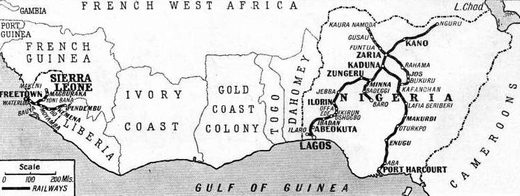
THE RAILWAY SYSTEMS of Nigeria and Sierra Leone are shown on this map. The Nigerian Government controls 1,772 miles of 3 ft 6-
The light railway is an interesting example of the development of the country. In 1884, while opening up the River Benue for trade on behalf of the Royal Niger Company, the late Sir William Wallace found that the tin used by the natives for tinning their brass-
The richness of the deposits discovered was such that tin-
This line was started in 1911, reached Naraguta in 1914, and was extended to Bukuru in 1915. This light railway brought the main tin-
The light railway still has its uses, however, and is a valuable feeder to the main line, especially for cotton traffic. It rises steadily from Zaria (2,140 ft above sea-
The main line of the Eastern System begins at Port Harcourt on the Bonny River This new port did not come into existence until after 1914, but it is second in importance only to Lagos. It is the port from which coal from the coal-
The Eastern Line was begun in 1913. It runs from Port Harcourt to Enugu, headquarters of the Southern Provinces (151 miles), and on to Makurdi (290 miles), Kafanchan (468 miles), and Kaduna Junction (569 miles). From Kafanchan a branch runs west-
It is a combined rail and road bridge and crosses the Benue River at the Munshi Narrows. It consists of ten deck spans of 180 ft. each, and three through spans of 240 ft each, carried on concrete piers faced with pre-
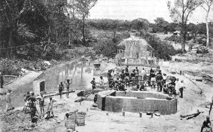
NATIVE BRIDGE BUILDERS. The foundations of the Pimmi railway bridge during construction. The bridge was built in connexion with the extension of the line north of Lagos. The illustration gives an excellent idea of the nature of the territory to be overcome.
The design was governed largely by the formations of the bank and the river bed, which are of sandstone except at midstream, where there is a deep, sand-
The piers and abutments contained 1,268,000 cubic feet of concrete weighing 84,900 tons, and 8,600 tons of steel and 700,000 rivets. Thirty-
The section of the Eastern Line between Enugu and Kafanchan, containing the Benue Bridge, passes through slowly developing country. It provides an alternative route for traffic from the north to the sea, by way of Port Harcourt, the second port in Nigeria.
A daily service of passenger trains is run between Port Harcourt and Enugu, and thrice weekly trains run from Port Harcourt to Kaduna Junction, and back.
The main line from Port Harcourt, which is about 180 ft above the sea, climbs up to two heights of about 750 ft before descending to 338 ft at Makurdi (290 miles). It then climbs another hill and descends to just below 500 ft at Barakin-
The train passes through the palm belt for the first 150 miles from Port Harcourt, the area producing palm oil in large quantities. There is a steady traffic in coal in either direction from Enugu, and in tin from Jos to Port Harcourt.
There were fifty-
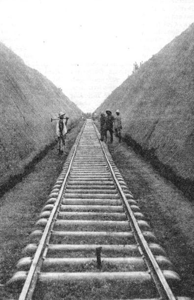
A DEEP CUTTING some sixty miles out of Lagos looking towards the town of Jebba, 303 miles from the coastal terminus of the Western Line.
The two locomotives with boosters were put into service in February, 1929, and after tests were put to work on the Mada-
The maximum permitted load for a locomotive on this section is 460 tons, distributed in from twenty to twenty-
On the Minna-
Regarded as a commercial proposition, the Nigerian Government Railway is not, at the time of writing, a profit-
Intense as the competition between road and railways has been in more settled countries, it has been rendered more acute in Nigeria. In recent years the administrators of the railway have taken the drastic step of halving the rate for third-
In modern development of hitherto unopened territory the responsible officials have three means of transport, railways, roads, and waterways. In Nigeria the roads have been made, particularly for the first 200 miles north of Lagos, parallel with the railway. Thus the roads, instead of feeding the railway, as in other undeveloped colonies, have become competitors. The lorries are acquired under the hire-
It is a remarkable sidelight on the rapid development of a colony which a few generations ago was the stronghold of slave-
The policy of the Government is to develop the railway in the interests of the African, not of the European. In this connexion the following figures are illuminating. All the station-
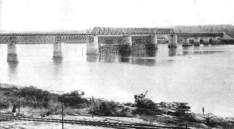
THE BENUE BRIDGE carries the Nigerian Government lines across the Benue River. The construction was begun in 1928 and finished in 1934. The bridge is one of the longest in Africa. Its total length is 2,584 ft. It has ten deck spans of 180 ft, and three through spans of 240 ft each, carried on concrete piers. The three middle spans, which are above the navigation channel of the river, stand 37 ft above flood level. The cost of building the bridge, including the two approaches, was more than £1,141,000 ; 8,600 tons of steel, 84,900 tons of concrete, and 700,000 rivets were absorbed in the construction of the piers and abutments. The bridge replaced a train-
The Government Railway of Nigeria is the only system of transport in the Colony which publishes its rates and time-
The four principal passenger trains are: the “North Mail” or “Boat Express”, from Lagos (Apapa Station) to Jos and to Kano, this train being called the “Ocean Mail” on the return journey to Lagos. The “Western Limited” runs from Lagos (Iddo Station) to Kano and back. The “Eastern Limited” runs from Port Harcourt to Kaduna and back. The highest average speed, including station stops, of any of these trains is only 20.48 miles an hour, and 22.76 miles an hour excluding station stops.
The section of the Western Line between Lagos and Ibadan is laid with 80 lb rails and is 120 miles long. A speed of forty miles an hour is permitted. Ibadan is the largest city in Nigeria, with a population of about 250,000. When passenger traffic justifies the experiment it is proposed to put Diesel-
The main workshops at Ebute Metta employ more than 1,500 Africans. They were erected in the early days of the railway. The workshops at Enugu, where about 440 Africans are employed, were equipped to serve the formerly isolated Port Harcourt line. Now that the two systems are connected most of the locomotive repairs are carried out at Ebute Metta.
The training of African workshops’ apprentices and firemen and engine drivers is interesting. Apprentices who have had a superior education and have shown marked ability in their work are selected for a more extended training than is usually given to ordinary and indentured trade apprentices.
Training Apprentices
Those selected will go through the locomotive workshops, have a year in the drawing office, and then spend three or four years in the Ebute Metta running shed, with a view to qualifying as locomotive foremen. Every encouragement is given to these African youths to qualify as mechanical engineers.
An obsolete locomotive of the 0-
Boys, preferably from secondary schools, are selected by competitive examination, and enter the training school for eight months, for a part of which they are engaged in cleaning engines. The second stage consists of six months in the erecting shop and six months with the fitters in the running shed. In the third stage they work as firemen on shunting duty, or on suburban trains. In the fourth stage they are main-

A THREE-
The salaries paid to European officials of the railway range downwards from the £2,000 a year plus £400 duty pay of the general manager. Locomotive drivers receive from £380 to £480, this salary scale being also that for shed-
The railway started the ground-
Sierra Leone has a longer history than any of the other Crown colonies in West Africa. The first explorer to arrive in the Bay of Sierra Leone is believed to have been Hanno, the Carthaginian, between 500 and 450 BC.
There are several versions of the derivation of the name. One was that the Portuguese sailors serving under Pedro da Cintra, who had been sent on an expedition by Prince Henry of Portugal and discovered the country in 1462, called the mountain Sierra Leone, or the Lion Mountain, because of the continual roaring of thunder on its summit, which was enveloped in clouds. It is more generally assumed, however, that the name was selected because, seen from the sea at a certain angle and distance, the mountain resembles a crouching lion.
In 1562 Sir John Hawkins paid his first visit to the coast and carried off 300 natives, took them across the Atlantic to Hispaniola, and sold them to the Spaniards as slaves. Early in the seventeenth century the English began to establish a regular trade. At the beginning of the eighteenth century Sierra Leone became a rendezvous for pirates. One pirate, a Captain Roberts, sent a boat to Governor Plunkett at the fort on Bunce Island to ask if he could spare any gold dust or powder and ball. The governor replied that he had no gold to spare, but he could have the powder and ball if he cared to call for it. The pirate vessels then attacked the fort. When the governor had exhausted all his ammunition, he tried to escape in a boat. He was captured and brought before Roberts, who swore at him for his impudence in resisting him. The governor swore back with such a rich vocabulary that the pirates laughed and told their captain that he had been out-
The beginnings of the colonization of Sierra Leone date from late in the eighteenth century. Many West Indian planters had been in the habit of bringing negro slaves with them back to England. In January, 1792, Lord Mansfield, Chief Justice of the King's Bench, gave judgment that a slave setting foot in England immediately became free.
About 15,000 negro slaves in England, affected by this decision, found themselves at once free and destitute. A proposal was accordingly made to find a home for them in West Africa. It was suggested by Dr. Smeathman, a naturalist familiar with the West Coast, that a grant of land should be obtained from the native chiefs and that the liberated slaves should be sent overseas to form a settlement.
The first ship left England in 1787. Other vessels followed; and the settlement of Freetown came into existence. In 1808 Sierra Leone became a Crown Colony, the population being 1,000.
To-
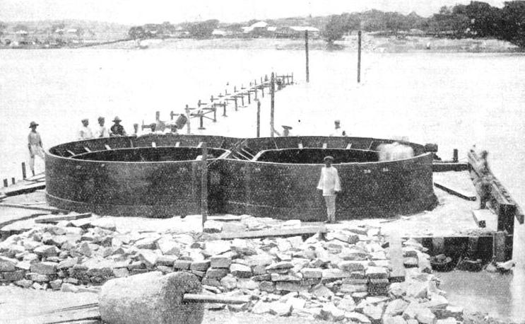
THE WELL CURB of a pier on the Niger Bridge which now carries the railway across the famous Niger River. Before the railway was built, the Niger, the Benue, and Kaduna rivers were the only satisfactory means of communication in Nigeria.
Freetown is now a well-
The motor roads in the Protectorate are of special importance, since they serve as feeder roadways to the railway and have thus done much to develop and increase the trade of the country.
Sierra Leone is roughly circular in shape, the maximum distances being about 200 miles, from north to south, and about 180 miles from east to west. After the Colonial Office had decided to open up the country by means of a 2 ft 6-
The first attempt to survey the interior was made by a party of three, consisting of a surveyor, his assistant, and a doctor, the doctor being indispensable owing to the then unhealthy nature of the country. The surface of the ground was covered with a thick layer of decaying vegetation, the putrefaction of centuries. The severe rainfall had converted this bed of leaves and branches into a spongy mass, interspersed with pools and swamps, where mosquitoes and other insects multiplied by the million. Malaria was rife, and disease was a formidable obstacle.
The three men had not gone far when the formidable nature of their task was brought home to them. The doctor went down with malaria, and while he was ill the assistant surveyor was struck down by the same disease and died. The surveyor turned the provisions out of the wooden boxes in which they had been packed for transport, made a coffin, and buried the assistant. Meanwhile he nursed the doctor. When the doctor was able to walk, the surveyor packed his gear and the two returned to the coast. But the pioneers were not defeated. Another survey was organized and carried out as soon as possible.
The work of construction was begun in 1896, and in May, 1899, the railway was opened for traffic for thirty-

“FIFTY-
After passing through the beautiful mountainous scenery of the peninsula of Sierra Leone, the line runs for almost its entire length through the Central Province. Although much of the country through which the railway runs is unattractive and apparently unproductive, feeder roads lead from all the oil-
The Northern Province is served by a branch line from the main line at Bauya Junction. This line runs up to Makeni, a distance of eighty-
At one time there was a branch line which ran for five and a half miles from Water Street Station, Freetown, through the central and western part of the town of Wilberforce and up to Hill Station, but this was closed in 1929 and a bus service was substituted. This mountain railway had a maximum gradient of 1 in 22, and a journey on it afforded a panorama of lofty, green-
The railway workshops are at Cline Town, a mile from Water Street Station. Most of the British railway officials live at Cline Town, where there are an institute, a cricket pitch, and a golf course.
The country traversed by the railway is particularly well watered. Thus the engineers found it necessary to build a large number of bridges. Omitting single-
The modern railway bridges of Sierra Leone contrast strangely with the “stick” and “hammock” bridges of the natives. “Stick bridges” are used to span narrow high-
Shallow streams and swamps are bridged in a similar manner by driving rough piles into the bed of the river or swamp and building the causeway on top of the piles. “Hammock bridges” are made by plaiting together long, thick, and tough roots, and suspending them between the branches of trees on either side of the river. Similar but smaller roots are suspended from these main “cables”, the principle of construction being exactly the same as in a modern suspension bridge A causeway, about a foot in width, is woven to the lower ends of the suspended roots, and a hand-
The locomotives total thirty-
The most important traffic on the Sierra Leone Government Railways is the transport of palm kernels, the oil from which plays such an important part in the manufacture of soap and candles.
The total mileage is 327½. Because of the fall in prices which has affected the railway there have been no developments in recent years.
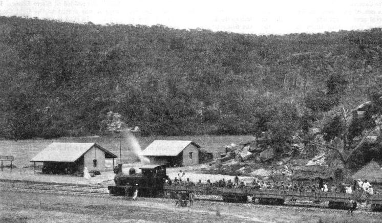
A TEMPORARY STATION at Port Weir on the northern extension of the Lagos Railway. The first line of the Lagos Government Railway was opened in 1901 to Ibadan, a distance of 120 miles. The northward extension later reached N’guru some 850 miles distant.
You can read more on “Across Africa by Rail”, “The Gold Coast” and “Unconventional Locomotives” on this website.