
© Railway Wonders of the World 2012-


Mexico’s Main Lines
Rail Travel in the Land of the Aztecs
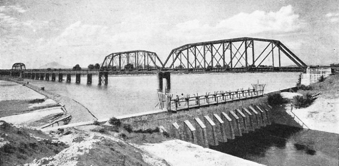
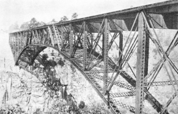
THE CULIACAN RIVER BRIDGE, built by the Southern Pacific Railroad of Mexico. This rail bridge is situated near Culiacan Junction on the west coast of Mexico. The railroad is a subsidiary of the Southern Pacific Company of USA, and controls 1,355 miles of 4 ft 8½-
THE railways of Mexico are considerable in extent, conquer mountainous country, and afford spectacular views. They are triumphs of engineering, and play a vital part in the economic development of the country. They operate some of the most up-
So closely related is the story of the railways with that of the modern history of Mexico that few countries have been so profoundly influenced by the invention of the steam locomotive. Mexico is a big country. The area is 768,900 square miles -
So high are the mountains that it is easy for the traveller to take a train from the heat of the sub-
Comprising a route mileage of more than 8,400, the organization known as the National Railways of Mexico is the most extensive railway system in the country, the various lines reaching from the United States to Guatemala and extending from coast to coast. For scenery, the British-
Development of the railways owes much to the vision of a remarkable man, Porfirio Diaz (1830-
President Diaz, who ruled the country -
The cargadore is still an important factor in the transport system of Mexico. When it comes to carrying a 150-
Building the First Line
Diaz saw that the railways would establish rapid transport for troops. Under his rule railways spread rapidly. For the first time since her independence Mexico had a settled Government, and not until old age defeated Diaz did disorder reappear. He helped to increase the railway mileage from 350 to more than 13,000 miles before he had to flee for his life. He gave a settled Government which attracted foreign capital, but he also saw to it that the railways were not controlled by foreign trusts.
The Mexican Railway is one of the most interesting, not only in Mexico, but also in the world. It runs from the port of Vera Cruz, on the Gulf of Mexico, to the capital, Mexico City, which has a population of about 1,000,000, and lies 7,349 ft above the sea. It is the oldest city in North America. The distance from Vera Cruz is 264 miles, and the journey is a continuous panorama, the line having to climb up to a height of 8,320 ft at Acocotla, the summit. Vera Cruz is so named because Cortes landed there on Good Friday, 1519, calling it La villa rica de la Vera Cruz, “the rich town of the True Cross”.
The first concession for building twenty miles of line from the port to the San Juan River was granted in 1842, but by 1849 only three miles had been laid, and it was not until 1854 that this section was completed. It was the first line in Mexico. The greater part of the railway was built in the ‘sixties, and it was opened for traffic on January 1, 1873. The gauge of this main line is the standard one of 4 ft 8½-
The route followed is that which Cortes took when he landed at Vera Cruz and started with his 500 Spaniards for Montezuma’s capital. Leaving Vera Cruz, the line proceeds through tropical country, passing plantations of tobacco, sugar-
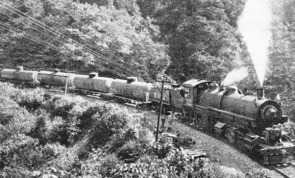
IN CENTRAL MEXICO. A train of fuel oil tanks hauled by an oil-
During the journey the snow-
At Fortin (seventy-
An Electrified Section
After a time the view widens. The train passes through a number of short tunnels, to emerge upon an extensive table-
Orizaba, with 50,000 inhabitants, is one of the most important manufacturing towns in the country, and enjoys a delightful climate, as it is situated between the tropical lowlands and the summit of the plateau. The Aztec name for it was Ahuaialixapan, meaning “Joyful Waters”, because of the many streams from the luxuriantly vegetated shoulders of the mountains. One of these torrents, the Orizaba, plunges through a ravine in the town. This stream was utilized by the Spanish in 1553 to work a flour mill, which was one of the first to be built in America. Just below the town, in the valley of Tuxpango, the waterfall is employed to generate electricity, which is used by the Mexican Railway to operate the mountain section of the line. The workshops of the line are in this town.
From Orizaba the line runs parallel with the Rio Blanco, crossing three tributaries of the river, and winds its way up through the Infiernillo (“Little Hell”) Canyon to Maltrata (ninety-
From Alta Luz (ninety-
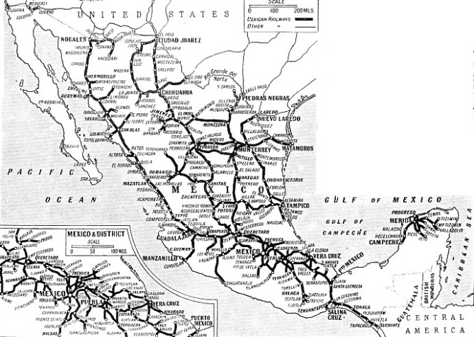
THE PRINCIPAL RAILWAYS OF MEXICO are shown on this map. The main groups are: the Mexican Railway, comprising 321½ miles of standard gauge, and over 108 miles of narrow-
From Esperanza the line passes through the plateau, with fields of corn and of the maguey plant much in evidence. This plant, the American aloe or pulque plant, provides the native drink of pulque. After the summit of the line at Acocotla (169 miles; 8,320 ft), the track drops to the junction station of Apizaco (177 miles; 7,920 ft) Apizaco is the junction for Puebla, as explained later.
From Ometusco (222 miles) a line branches off to Pachuca, a centre for one of the richest silver mining districts in the world. At Teotihuacan (236 miles) the Pyramids of the Sun and of the Moon, and the Temple of Quetzalcoatl are seen. The capital is approached through Guadaloupe, where there is a famous shrine. The Mexico City terminus of the line is at Buena Vista Station, 264 miles from Vera Cruz, the administration offices of the company being in the station building.
A Startling Event
Before the electrification of the mountain section, “Fairlie” locomotives were employed on this line. The early locomotives were wood-
One engine caused a great commotion. It was run into the siding at the top of a climb and the crew left it for a meal, when it moved off so quietly that they did not hear it until it had gathered speed. The driver and firemen then turned, and were horrified to see that it was running away. They set off in pursuit, but were too late, as it dashed over the points on to the main line. The only thing that could be done was to telegraph all down the hill, warning everybody. Trains were hurriedly shunted into sidings out of the way of the truant. Everybody waited for the crash to come when the engine would shoot off the track and over the precipice. But it never came. Although the locomotive reached a speed of sixty miles an hour, it kept on the rails and finally came to a stop thirty miles away on an adverse gradient, having rounded all the twists and turns.
On the principal bridges of the mountain section a guide is added to the train crew, and any possibility of a train approaching at an excessive speed is checked by the necessity of stopping the train before the bridge to pick up the guide. The maxi-

TRAIN No. 1. The through express from Mexico City to Laredo, Texas. There are two trains which daily depart in either direction on the journey of just over eight hundred miles. The above picture also clearly shows a power-
There are two expresses daily in either direction between Mexico City and Vera Cruz. The daylight service expresses have reclining-
Vera Cruz in the old days was not a health resort. One American who arrived by railway from Mexico City had heard such tales of yellow fever that he was horrified when he ventured forth in the morning and saw red flags flying from various establishments, because he thought they meant that “yellow jack” was rife. He found later that the flags indicated that a fresh supply of pulque had just arrived by rail from the plateau, for the railway taps a part of the country celebrated for its brew of this liquor. In 1914, when US Marines were landed to deal with local trouble, the Americans cleaned up the port. When they left the city authorities made efforts to continue this good work and the place is now considerably healthier.
A branch goes north from the main line at Cordoba to Coscomatepec, but the gauge is only 2 ft. The trains have to climb up from Cordoba, 2,704 ft, to about 5,000 ft in the twenty miles of the line by a gradient as steep as 1 in 30 on one section. Two trains daily make the climb in about two hours, and the pedlars of fruit, flowers and sweets who offer their wares to the passengers at the lower stations take short cuts up the hills and meet the train at the higher stations, cutting prices as they ascend until they are sold out.
From San Marcos, 151 miles along the main line from Vera Cruz, a 3 ft gauge line fifty-
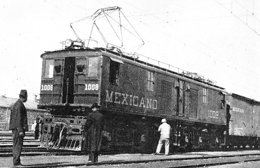
AT ESPERANZA STATION, a junction on the lines of the Mexican Railway, 112 miles from Vera Cruz. The train is headed by one of the powerful electric locomotives with overhead collectors which are used on this system. Trains for Mexico City change over from electricity to steam at Esperanza.
The next branch from the main line is at Munoz. From Munoz a 2 ft 6-
The total length of track and sidings owned by the company is over 300 miles standard gauge and 108 miles narrow gauge. Ten locomotives are narrow gauge and seventy-
Another route from Vera Cruz to Mexico City is provided by the Inter-
National Railroad .. .. .. .. .. .. .. .. .. .. 1492·6 miles
Central Railway . .. .. .. .. .. .. .. .. .. .. 3586·7 miles
International Railroad .. .. .. .. .. .. .. .. 1130·8 miles
Vera Cruz & Isthmus Railway .. .. .. .. ..340·5 miles
Pan-
Hidalgo Railroad.. .. .. .. .. .. .. .. .. .. .. ..131·7 miles
Miscellaneous leased or private lines . ..146·5 miles
Total mileage .. .. .. .. .. .. .. .. .. .. .. .. 7114·5 miles
Lines such as the Inter-
About one-
Out of the 34,455 persons on the books of the company all except fifteen are Mexicans. Twelve of the foreigners are employed in foreign agencies, another is Vice-
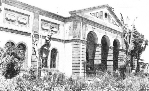
IMPOSING ENTRANCE to Puebla Station, which is served by the Mexican Railway and the National Railways. By the National Railways’ line, Puebla is a 130 miles journey from Mexico City.
In recent years the railway tourist traffic has developed with the co-
Mexico City is the headquarters of the system. The terminus of the lines from the United States border and from certain towns in western Mexico is the Colonia Station. The Buena Vista Station is the terminus of the lines of the Mexican Central section, and near it is the terminus of the Mexican Railway. These three stations are on the north side of the city. On the south-
The main line of the National Railways extends south from Nuevo Laredo, on the Rio Grande, to Mexico City, passing through Monterrey, Saltillo, San Luis Potosi, and Queretaro -
The train crosses the river to Nuevo Laredo by an international bridge and enters Mexico at an altitude of 457 ft. It ascends to 1,771 ft at Monterrey (168 miles), a city of 150,000 inhabitants and an important railway junction and industrial centre. This part of the journey provides little in the way of scenery in the progress across the plains until Monterrey is approached; it is probably the route by which the early tribes reached Mexico. After leaving the city of Monterrey the line begins to
climb up to the great plateau. In the ‘forties the invading American Army under General Taylor fought its way south along this route.
Saltillo (235 miles) lies at an altitude of 5,249 ft, and is a city of 48,300 inhabitants, with a history dating back to 1575, when the Spanish discovered the region. The line continues to rise, crossing the Tropic of Cancer, and goes through a rich mining district. The track has swung to the west from Monterrey to climb to Saltillo, after which it turns south. The line ascends between the hills, reaching at 241 miles Buena Vista, where General Taylor and his 4,700 Americans defeated 23,000 Mexicans under General Santa Anna in 1847. The gradient is stiff to Carneros (259 miles), the line reaching the top of the plateau at an altitude of 7,300 ft. The great haciendas -
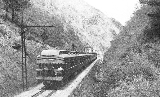
IN “LITTLE HELL” GORGE, or Infiernillo Canyon, on the line of the Mexican Railway between Vera Cruz and Esperanza. The rail journey from the harbour to Mexico City via Esperanza is a continuous panorama of fine scenery. The summit of the line lies 8,320 ft. above sea-
San Luis Potosi (477 miles; 5,938 ft) is a mining city, which was exploited by the Spanish who worked the mines in this district. It is a junction for the line from the port of Tampico. After leaving San Luis Potosi the line passes through a flat valley, and then a stony region of steeper gradients, emerging into more fertile lands.
Empalme Escobedo (609 miles) is an important junction, and the line here turns to the east. Queretaro (637 miles; 5,938 ft), with 37,000 inhabitants, is rich in minerals, opal mines being near by. The Archduke Maximilian was shot on a hill outside this city with two of his generals, after the President of the United States, Queen Victoria, and the French and Austrian Emperors had tried to save his life by an appeal to the Mexicans. Before he died Maximilian asked the firing squad to shoot him in the body so that when his remains were sent to Austria his mother might see his undisfigured face. A chapel was erected on the site of the execution at the expense of the Austrian Government.
The line winds upwards again. At La Griega, 646 miles, it gains an upland fertile plain, which broadens to a region of fruit trees for some miles until again the land becomes rugged, and another climb begins. Huichapan (704 miles) is passed, and at Nopala (716 miles) the train climbs above the elevation of Mexico City to the summit of the line, and then descends; but it has to make another ascent to gain an entrance to the Valley of Mexico.
This valley is shut in by hills, and the track is led first through a deep cutting and then through a tunnel, 735 ft long, which is the only double-
Across the Gorge
The narrow gauge line had numerous gradients at 1 in 50 or steeper. The most severe was at 1 in 25 on the way to the summit at La Cima, beyond which was a descent at 1 in 26 to reach Mexico City. It was therefore decided not only to broaden the gauge but also to find a less severe route.
The present line branches from the old one in the section south of Queretaro; the steepest gradient is now 1 in 50 and the summit-
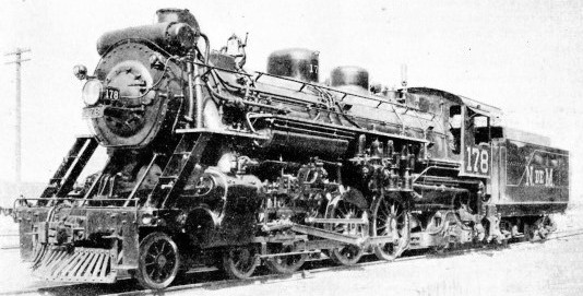
LOCOMOTIVE No. 178, one of the 4-
The earthworks were considerable. At the seventy-
At Mile 120 a smaller gorge was filled, and the new line soon began to pay its way because of the lower fuel costs.
Another route into Mexico is that via Eagle Pass by a line which joins the route just described at the junction station of Saltillo. Eagle Pass is in Texas, the town on the Mexican bank of the Rio Grande being Piedras Negras. Piedras Negras is 273 miles from Saltillo and 841 miles from Mexico City. Trains from the United States reach Piedras Negras from San Antonio. Sabinas, seventy-
The most easterly gateway is afforded by the Brownsville-
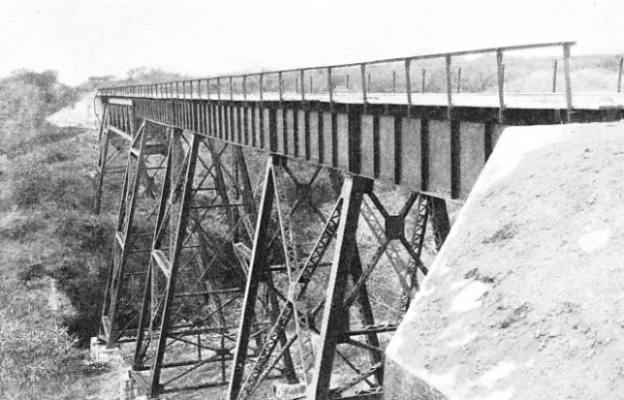
A NEW TRESTLE BRIDGE on the lines of the National Railways of Mexico. This fine steel structure is crossed by trains running between Guadalajara, a junction, and Manzanillo on the west coast of Mexico.
The route which keeps practically in the centre of Mexico is that from El Paso-
Construction began at either end, and the lines met at Fresnillo, 752 miles from the border, in March, 1884. The occasion was a ceremonious one. The American Consul at Zacatecas was on the engine from the south, and his brother, a Mexican citizen, was on that from the north. The American brother waved the Mexican flag and the Mexican brother the American flag, and the brothers saluted each other, as symbolical of the meeting of the lines from the two republics. This line was built by Americans with American capital.
Over the Rio Grande
El Paso is on the Texan side of the Rio Grande, and the train crosses the international bridge to Ciudad Juarez, in Mexico. This town was formerly Paso del Norte (Pass of the North), but was renamed to commemorate President Juarez. The altitude of the station is 3,717 ft, and the American engineers took the track to Mexico City through the mountains without one tunnel, although they had maximum gradients of 1 in 57. The line was standard gauge from the beginning, and was built in about four years, at an average rate of a mile each working day.
Going south through country which was once the haunt of Apache raiders and smugglers, and passing (114 miles) the station of Moctezuma (Montezuma), the line reaches the first town of any size -
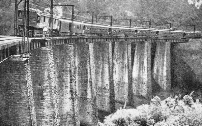
THE METLAC BRIDGE on the Vera Cruz-
Mineral-
Jimenez (373 miles) is the junction for the branch line which runs west to Parral and Rosario, with spurs to other towns. A church at Parral was completed in 1710 at the expense of an Indian miner, who brought a bar of gold every Saturday to pay the builders. When the church was finished the officer in command of the district seized the Indian and ordered him to show the way to the mine. The Indian refused and was put to the torture. As he would not speak he was tortured to death. The mine has never been found.
Escalon (419 miles) is a junction for a line going north-
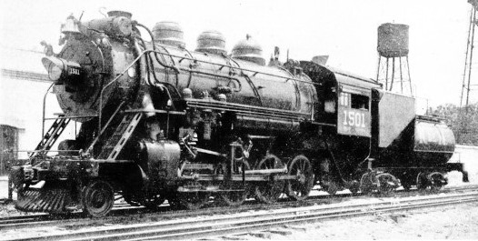
2-
From Torreon the trunk line forms a bight for nearly 200 miles to Canitas, or Felipe Pescador, which is the junction for a second branch to Durango, and is 719 miles along the route. Zacatecas (788 miles) lies as high as 8,010 ft, the gradient having been adverse all the way up from Torreon, which is 3,721 ft above the sea. The worst part of the climb is packed into the last nine miles from Pimienta (779 miles), which require twenty-
Tula (1,177 miles, and fifty miles from Mexico City) is a village of 2,000 inhabitants. It was the capital of the mysterious Toltecs, who appeared in Mexico for about four centuries and disappeared about the eleventh century. The line gains the valley by means of the Tajo de Nochistongo, or “Cut of Huehuetoca”, a trench once nearly four miles long that was cut through the mountains to drain the Valley of Mexico. Work started in 1607, the first plan being to drive a tunnel, and some 15,000 Indians were forced to labour, thousands dying from hardships. The tunnel was made, but in 1629 the engineer became nervous, and had it walled up during exceptional rains, so that Mexico was flooded. The engineer was put in prison and kept there until he proposed to convert the tunnel into a ditch. This meant more trouble with the Indians, who were always trying to desert. The work was not really finished until just before the beginning of the nineteenth century. Huehuetoca (1,198 miles) is at the top of the last gradient, and after this the train speeds up and gains Mexico City, 1,226 miles from the start.
Tampico, with a population of 100,000, is the great oil port. It has grown from a small town since 1901, when the oil industry began to develop. Two main lines run from it, one west to San Luis Potosi, and the other north-
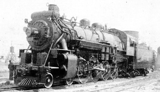
SAFETY FIRST is the meaning of the Spanish words “Seguridad Ante Todo”, painted on the front buffer beam of this 4-
East of Mexico City the system of lines is considerable. The narrow gauge Interoceanic Railway to Vera Cruz competes with the Mexican Railway. Beyond Vera Cruz the National fines intersect the Tehuantepec Railway, which runs from Puerto Mexico, on the Gulf of Campeche, across to Salina Cruz on the Pacific, while a further link of the National lines runs parallel with the south coast to the border of the Republic of Guatemala.
“Poison Trains”
The Tehuantepec Railway is of particular interest as it was built across the narrowest part of Mexico as a transcontinental route of standard gauge. It was begun in the ‘nineties at a time when the completion of the Panama Canal was regarded as impracticable after the failure of the French attempt.
The original line was later improved, and important harbour works were completed at Salina Cruz. In 1907 President Diaz and a large party went to Salina Cruz, where the President set in motion a steam winch which lifted the first piece of cargo from a ship into a goods wagon. The party then went across the isthmus to Puerto Mexico, where the load was put aboard a ship. Puerto Mexico was formerly known as Coatzacoalcos, but the name was changed in honour of the occasion. Before the Panama Canal was opened, most of the goods for California and British Columbia were taken by the Tehuantepec Railway. It became also a link between Mexico and the republic of Guatemala. The distance by rail across the isthmus is 188 miles. There is one through train daily in either direction, the journey time being about twelve hours.
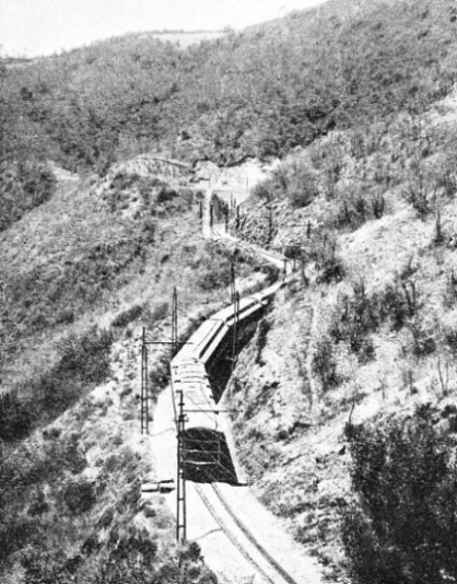
GRADIENTS OF 1 IN 22 are encountered on the journey by trains of the Mexican Railway bound for Mexico City. The above illustration shows one of the steep gradients near Alta Luz, ninety-
The line leaves Puerto Mexico, and goes through tropical country of such rank vegetation that “poison trains” have to be employed to prevent the jungle from overgrowing the track. Santa Lucrecia (seventy-
The Tehuana women are energetic, enterprising, and attractive; they greatly outnumber the men. It is said that the shortage of men is the result of the civil wars, Pearson is the British name given to the last station before Salina Cruz. The name is in honour of the Briton who is remembered in Great Britain as the first Lord Cowdray. The great firm of Pearson did much to develop modern Mexico, and built the railway and the port of Salina Cruz.
The Pan-
An Aztec Stronghold
Puebla, which is 130 miles from Mexico City by the National Railways line, is, as mentioned previously, also on the Mexican Railway. It is connected with Oaxaca by the line of the Mexican Southern Railway, which is part of the lines operated by the National Railways. Trains take about six hours for the journey to Puebla, and about twelve hours for the 228 miles thence to Oaxaca. Mexico City is 7,349 ft, Puebla 7,069 ft and Oaxaca 5,067 ft above the sea, and this journey is one of the most beautiful in the country, as the scenery is varied, and the snow-
Oaxaca, with a population of 40,000, was first an Aztec and then a Spanish stronghold. During the revolutionary struggle against Spain the revolutionaries made a point of executing the royalists on the spot where the royalists had executed revolutionaries. The town does not mark the end of the line, as spur lines extend east, west, and south, in the manner of the roots of a tree.
Away to the east of this railway is the line of the Vera Cruz and Isthmus Railway (National) in the form of a twig. One fork of the twig rests on Vera Cruz, the other on Cordoba, and thev join at Tierra Blanca, which is sixty-
MODERN ALL-
A National line famous tor scenery is that from Mexico City south through Cuernavaca to Balsas, a distance of 182 miles. The first part of the journey affords wonderful views of the Valley of Mexico, and the building of this section was a feat even in this country of remarkable railway engineering.
The original plan was to carry the line through to the Pacific port of Acapulco, but this was not done. The railway builders were unable to avoid a gradient of 1 in 33 to reach Cima (9,895 ft), and a similar gradient for the descent, the summit being thirty-
The newest routes from the United States, independent of the National lines, is that of the Southern Pacific Railroad of Mexico, which is a branch of the Southern Pacific Company of the USA. This line is the western gateway to Mexico. It enters the country at Nogales, and runs near the Pacific coast, which it approaches near Guaymas, and connects with the National system at Guadalajara, for access to Mexico City. This route, opened in 1927, has attracted traffic from California. An air-
After leaving the capital, passengers are given half a day in Patzcuaro, a day and two nights in Uruapan, nearly a day in Morelia, and some hours in Celaya. The car then goes up the central trunk line of Mexico to El Paso (Ciudad Juarez), where it crosses into the United States. This trip is worked in the reverse direction from El Paso, where passengers from New Orleans and Chicago join it, the tourists from Los Angeles entraining at Tucson.
The "Hotel Car"
The “hotel car” is self-
The distance from Nogales to Guadalajara is 1,095 miles, and from there to Mexico City is a further 381, making a total of 1,476 miles. Although the line enters Mexico at an elevation of 3,869 ft at Nogales, this is no advantage, as there are many ups and downs due to the fact that it touches the sea. In its first few miles it climbs to 4,288 ft, it comes down to only 53 ft at Poza (118 miles), climbs to 1,520 ft, at Carbo (130 miles), and drops to five feet at Empalme (255 miles).
Guaymas, five miles farther on, is on the Gulf of California, but the main line runs parallel with the coast, some distance inland, sending out branches to various ports until it reaches the port of Mazatlan (729 miles). As far as Roseta (891 miles) there is not a station all the way from Empalme, which is as much as two hundred feet above sea-
There are sixteen tunnels (two nearly three miles long) in as many miles, twelve viaducts, and many fills and cuttings -
Thus the railway conquest of Mexico has been as remarkable in its way as the conquest by Cortes, as practically all the lines have to overcome very difficult problems. The summit-
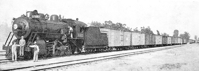
ON THE SOUTHERN PACIFIC SYSTEM. A long train of freight cars hauled by a 2-
You can read more on “The Magic of the Andes”, “Main Lines of Brazil” and “North American Railroads” on this website.