
© Railway Wonders of the World 2012-


Pioneering in Nyasaland
An Important Link with the East African Coast
RAILWAYS OF THE COMMONWEALTH -
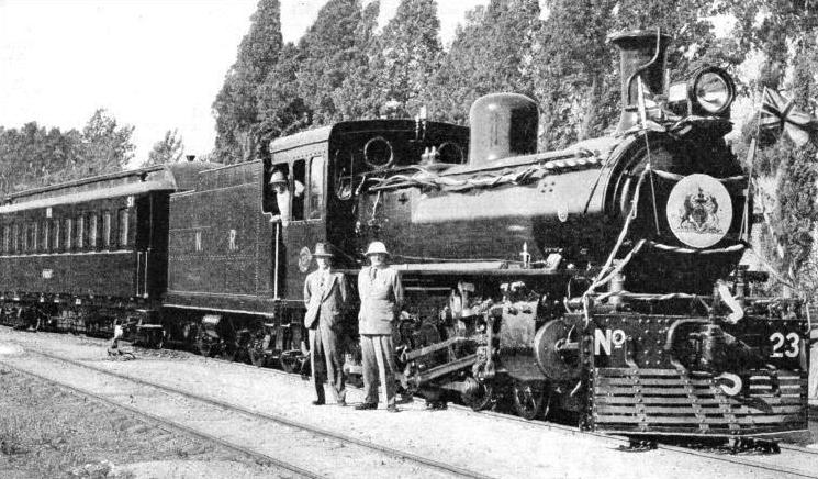
A SPECIAL TRAIN for the Governor of Nyasaland. The railways under his jurisdiction have 273 miles of 3 ft 6 in gauge track.
THERE are few railway systems more interesting than that which connects Lake Nyasa with the growing port of Beira in Portuguese East Africa. This system, completed in 1935, is composed of the Nyasaland Railways, the Central Africa Railway, and the Trans-
Jasper Bocarro, a Portuguese, is said to have been the first European to set eyes on what is now Nyasaland, travelling in the country early in the seventeenth century; but authentic history begins with Dr. Livingstone. That indefatigable explorer ascended the River Shire, discovered Lakes Chilwa and Pamalombe, and reached the southern shore of Lake Nyasa in September, 1859.
Lake Nyasa, the third largest lake in Africa, is 360 miles long, ten to fifty miles wide, and has an area of 14,200 square miles. Its greatest depth is 386 fathoms, and it lies 1,555 ft above sea-
Arab slave traders used to cross Lake Nyasa on their way to and from the coast, and the opposition of the early European settlers led to a conflict with the Arabs who had settled at the northern end of the lake.
The first settlers hoped to find a navigable waterway from the coast to the lake. The country could be entered at Chinde on the delta of the Zambesi in Portuguese Territory, and the river could be navigated to its confluence with the Shire River, up which shallow-
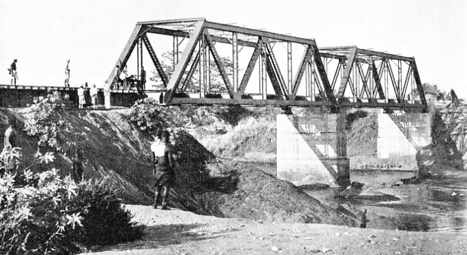
STEEL AND CONCRETE. Two of the large spans of the Lintipe Bridge, which carries the track of the Nyasaland Railways across a wide river. The bridge is on the 160 miles stretch between Blantyre and Salima, the present terminus of the railway.
The young settlement was thus cut off from effective transport with the sea and the outside world. Expansion was hindered. The British Central Africa Company decided at the beginning of the twentieth century to build a railway between Blantyre and Port Herald. The line would not only lower the cost of transport, but would also provide a means of breaking up the slave trade around the lake. The length of the railway was only 113 miles, but a difference in level of 3,700 ft had to be conquered. The broken character of the country added to the difficulties, as rifts in the hills, dry in summer, became raging torrents in the wet season.
The struggle with the Shire River started at the very beginning, as the first plan was to connect Blantyre by a line only eighty-
Railways in undeveloped countries generally begin at the coast, but this one was different. Every scrap of material had to be shipped out from England to Beira, transhipped into coasting vessels for transport to Chinde, where it was loaded in shallow-
Far-
The country was in such a primitive state that nothing could be obtained locally -
With a view to speed and cheapness in construction, and because of the expected lightness of the traffic, the company had planned a narrow gauge, but the Government authorities in London insisted upon the South African standard gauge of 3 ft 6-
No coal and no lime were to be obtained locally at that time, and bricks could not be made to help in the erection of the piers. There was no stone good enough to be used as masonry. Portland cement, imported from England to make concrete, cost five or six times the original price by the time it reached the site, because of the cost of transport. But careful organization and rigid attention to every detail ensured success, and the material reached Port Herald; natives were even-
An incident in the beginning throws light on the strange problems that the railway pioneer has to solve in a primitive country. In addition to the hills, rivers, floods, heat, insects, and sickness, he has to contend with the psychology of the natives coaxed to build the track. Before the railway began there was no money in circulation among the natives, who, in fact, did not know what money was, as there was no coinage. But they knew what cloth was, and this was the recognized currency. The Government, however, refused to allow the natives to be paid in cloth, so the labourers had to be taught the value of money.

ON THE TRANS-
The line followed a northerly course from Port Herald roughly parallel with the River Shire as far as Chiromo. It then crossed the river by a, bridge about 420 ft in length to reach the valley of the Ruo River.
This bridge, a fine piece of construction, was another example of what makes railway pioneers philosophers when caught between the upper millstone of a Government order and the nether millstone of a river with the diabolical tricks of the Shire.
Although the attempt at establishing the base of the railway had been foiled because of the unsuitability of the river for navigation, the Government stipulated that the railway bridge should not interfere with navigation. Since the railway was built the river has been very little used. The Government demanded, however, that the proposed bridge should have an opening 100 ft wide, giving a head clearance of 30 ft at high water. The ordinary drawbridge or swing-
The engineers designed a lifting span of interesting design. They realized that it would have to be simple and easily operated by hand, as natives would have to be employed to open and close the bridge. On the top of each of the two piers carrying the lifting span they erected a tower, with two single vertical racks on each to act as a guide. A platform was built on the top of the tower with a large sprocket wheel at either end. A chain passed over each sprocket wheel, one end being made fast to a corner of the lifting span, and the other to a counterweight.
Wasted Invention
To open the bridge the natives wound a winch which turned the sprocket wheel. As the counterweight descended the lifting span rose up the racks on either tower until it was at the top. When it was in this position the counterweights on the out-
This ingenious structure was shipped out from Great Britain and was erected; but directly it was in position the River Shire changed its course, so that the navigable channel shifted from under the lifting span to under a fixed span. The lifting span was thus a waste of time, money and effort, as it was never used.

4-
Some twelve miles north of Chiro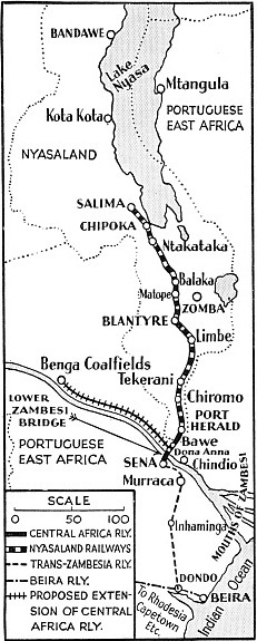 mo the line begins a stiff climb through broken country to reach the plateau, at an altitude of 4,000 ft. The ruling gradient is 1 in 44, and the minimum curve of 363-
COMPLETED IN 1935. This map shows a system covering some 500 miles, which includes the Nyasaland Railways, the Central Africa Railway and the Trans-
The line took about seven years to build. The natives proved poor workmen. They dodged work as much as possible, and when the rainy season, which lasts about three months, set in, they deserted the line to cultivate patches of land, and did not return until the rains were over. At that time, when the science of tropical medicine was far from its present standard, the mortality among the Europeans was severe. On this account the repair shops and administration offices were established at the summit level, Limbe, five miles from Blantyre, one of the healthiest places in the country.
This Shire Highlands Railway, as it was originally called, was opened to traffic in 1908, and soon after this the Shire River again set the engineers a problem by falling considerably, until at last navigation by river to Port Herald became so difficult that the building of a railway south from the terminus to Chindio had to be considered. A line, sixty-
When the war of 1914-
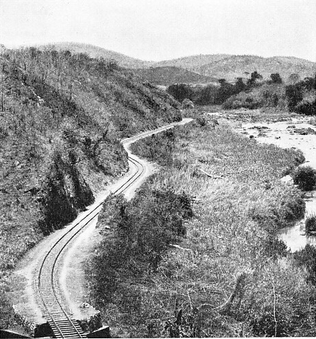
The photograph shows a section of the railway in Nyasaland, which follows a tortuous course through the valley of the River Ruo, north of Chiromo.
After the war the need for connecting the Zambesi Valley with Beira by rail, both to develop the Mozambique Company’s territory in Portuguese East Africa, and to improve communication with Nyasaland, resulted in the building of the Trans-
Before the Trans-
As far back as 1894 a railway was projected, a survey was made for the Trans-
The carrying of the line from Murraca to Sena, for the new bridge, meant building an extension of twenty-
For three-
The annual average of goods traffic for the five years ended 1933 was 85,871 tons. In 1930, a record year, 22,260 passengers were carried.
A Dismantled Section
When the bridge at Sena was opened -
The whole length of line from Beira has at present only one short railway feeder, a 3 ft gauge track belonging to the Sena Sugar Estates which connects a sugar factory at Marromeu on the Zambesi with the Trans-
The northern extension from Blantyre to Lake Nyasa is 160 miles in length, and terminates at Salima. There is a short branch to Chipoka Quay, on the shore of the lake. The original intention to make Domira Bay, on the shore of the lake north of Salima, the terminus, was checked by the action of Lake Nyasa in rising to an unusually high level. The line is the only railway that reaches Lake Nyasa, and the only railway connexion from the lake to the sea.
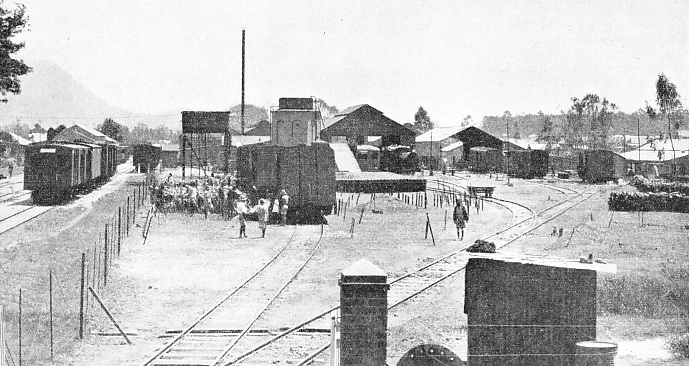
THE DEPOT OF NYASALAND RAILWAYS AT LIMBE, on the main line between Port Herald and Blantyre. The railways possess at present twelve locomotives, two “Sentinel Cammell” rail-
Northward from Blantyre the first twenty miles of the new line passes through hilly country, the ruling gradient being 1 in 80, but the remainder of the distance is easier. The importance of the terminus lies in the fact that Salima is connected by road with the tobacco-
Nyasaland, with Northern and Southern Rhodesia, is the most important source of tobacco in the British Empire, and the value of Nyasaland’s tobacco exports is seventy per cent of her total exports. Other crops are maize rice, cotton, tea, coffee, and sisal. The country is entirely agricultural, no minerals of commercial value having yet been discovered. The new railway development will open up an area of fertile lands by providing cheap transport, especially around Lake Nyasa. One of the first big transport jobs on the new line was the hauling up to the lake from Beira of a Diesel-
When the northern extension was constructed 112 of the 160 miles from Blantyre to Salima were built in a year. The principal bridge is the Lintipe Bridge, which has two spans of 100 ft and four spans of 50 ft, but there are three hundred minor bridges and culverts. The line from Blantyre to Mile 30 was ballasted with weathered rock excavated from cuttings. Coarse sand from river beds was used for the next thirty miles, for a further thirty miles good ballast was obtained from a quarry, and thereafter coarse river sand was used.
There was no shortage of water. At one point a rainfall of over four inches in less than two hours was registered, while at another the track was flooded for several days. Near the Livilezi River the overflow from a point a thousand feet above the track damaged the bank.
The northern extension has made hunting grounds easily accessible for big game hunters in quest of elephants, buffaloes, and hippopotami. All equipment is on sale at Blantyre; but the hunter has to make a road trip of some forty miles to Zomba, the headquarters of the Administration, which is not on the railway, to obtain his game licence.
The equipment of the railways is up-
The Nyasaland Railways possess twelve locomotives, two “Sentinel Cammell” rail-
Kitchen and Brake Van
The D class locomotives have the 4-
Each railway has a combined kitchen and brake van, which is 60 ft in length, and is designed to carry 20 tons, the tare weight being over 34 tons. It is equipped with a coal-
The “Sentinel” steam rail-
Track maintenance presents problems unknown in temperate climates. In addition to the usual troubles, due to torrential rain in the hills and floods which damage earthworks, the railway has locusts to contend with. On one occasion the loads of goods trains in one section had to be reduced for a period of several weeks, as the crushed bodies of the insects caused the wheels to slip.
As we have seen, the railway in this section of Africa has developed partly because of the vagaries of the Shire River, which caused the pioneers to build a reliable, cheap means of transport as the only way to open up a country of great possibilities. It is significant that a country inhabited by fewer than 2,000 white people is now served by a system of lines consisting (including the Trans-
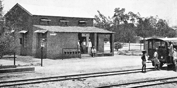
A STATION IN THE TROPICS. Balaka, a halt on the lines of the Nyasaland Railways is seen here. The roof above the “platform” is thatched.
You can read more on “Across Africa by Rail”, “In the Nile Valley” and “Progress in Rhodesia” on this website.