
© Railway Wonders of the World 2012-

The Great St. Gothard
How Switzerland’s Wonder-

GÖSCHENEN, a small Swiss town 3,640 ft above sea level, which stands at the northern portal of the famous St. Gothard Tunnel.
SWITZERLAND, by reason of its central position in Europe, is a focal point of railway communication. Through this small country pass several of the most important of the trans-
The most spectacular feats of engineering have been achieved by two of these main lines cutting across the Alps from north to south, on the way down to Italy. Of these, the older established, and the first Swiss main line to cross the Alps, is the famous St. Gothard Railway.
Throughout history the St. Gothard Pass has provided a highway through the Alps. As far back as the thirteenth century, pilgrims to and from Italy used it; and a hospice for their shelter has existed for over five hundred years on the summit. Following them came the merchants from Basle and Zurich, desiring to form trading alliances with the rich cities of Lombardy, and with Milan in particular. By the fifteenth century an irregular post had been established over the narrow mountain track; by 1693 this developed into a regular postal service twice a week.
Just over a century later the Swiss Republic assumed the responsibility; by 1820 a road had been made up to Göschenen, and by 1834 the road had been carried over the St. Gothard Pass. In 1842 the postal service started to run every day, and passengers, up to eight in number, were allowed to ride in the post-
Thus it was that, with railway communication spreading all over Europe, attention became directed towards the possibility of cutting a railway through from Central Switzerland to North Italy, to provide a direct route, not only from Basle and Zurich, but also from Germany and beyond, into Italy. The far-
Up these rugged Alpine valleys, roads could be carried at inclinations as steep as 1 in 10 -
As these Alpine valleys rise with progressively increasing steepness into the heart of the mountains, it was realized that the point at which it would become impracticable to lift the railway any higher would be reached, a considerable distance away from the crest of the Alps. Recourse to tunnelling would then be imperative, in order to cut through to a valley on the south side of the range which would lead the line down into Italy. It was clear that the tunnel would have to be of greater length than any railway tunnel previously attempted in any country.
The increasing importance of the St. Gothard road naturally suggested a similar route for the proposed railway. But the supporters of the St. Gothard Railway met with considerable opposition. A strong body of Swiss opinion favoured a route farther to the east, by way of the Lukmanier Pass; this would have come up the Rhine valley to Disentis, there turning south through the Lukmanier, and joining at Biasca the Val Leventina, down which passed the St. Gothard road. The Federal authorities, however, finally decided, in 1869, on the St. Gothard route, and events have since proved that in more respects than one they made a very wise decision.
Work on this colossal undertaking did not begin until 1872, and it continued for ten years, until the St. Gothard Railway was opened throughout its length. Owing to many and unexpected difficulties, the original estimates were swollen until the final expenditure reached £4,760,000.
To those acquainted with present-
Apart from the 9¼ miles of the great St. Gothard Tunnel, a further 19¼ miles of tunnels, 79 in all, of varying length, seven of them spiral in plan, had to be bored; 324 bridges, some of them massive viaducts, and all of more than ten metres (32 ft 10 in) in span, had to be thrown across gorges, rivers, and smaller streams. An immense amount of blasting had also to take place in order to fashion along the mountain sides the shelves on which the railway was to be laid.
Incidentally, by reason of the detours entailed in circumventing Nature’s obstacles, and in following the sinuous course of her valleys, the distance of 90 miles from Lucerne to Chiasso, as the crow flies, became 140 miles along the best railway route that could be devised.

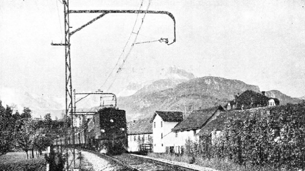
KERSTELENBACH VIADUCT carries the St. Gothard line over the Kerstelen Gorge with its foaming stream plunging from tne Maderaner valley. In the right foreground is seen the Amsteg Hydro-
Lucerne is the starting point of the St. Gothard Railway. The bulk of the traffic passing over this railway has come through Basle, the principal northern traffic gateway of Switzerland. There, in the great Hauptbahnhof, or Central Station, coaches from many European countries -
After passing through the Jura mountains, the south-
With an electric locomotive -
After passing in a long semicircular tunnel under Lucerne, the line is compelled to turn through a right-
Mountain Barriers
The southern end of the Lake of Lucerne, known as the Lake of Uri, is its grandest part. The water is pent between great cliffs, themselves backed by high mountains, whose basins enfold the blue-
Opening up ahead, to the right of the shapely cone of the Bristenstock, is the valley of the Reuss, up which the railway is now to pass. Silt brought down in ages past by the rushing river has flattened the mouth of the valley, so that the track is comparatively level until Erstfeld is reached. The line here lies 1,558 ft above the sea, and 37½ miles from Lucerne; as yet it has climbed no higher than 108 ft above the level of the lake.
The main gradient now begins. In the next eighteen miles a total rise of 2,082 ft is to be negotiated. This will lift the railway to an altitude greater than the summit level of Snowdon, 3,571 ft. Therefore, over the whole of this section of line the locomotives have to climb continuously up a gradient which varies between 2.2 and 2.6 per cent -
When it is realized, by way of comparison, that the worst pitch of the famous English ascent to Shap Summit, in West-
On leaving Erstfeld, the railway begins climbing steadily on the east side of the valley, until it is high above the valley floor, when it reaches Anisteg. This is in anticipation of the rapid rise of the valley itself, which takes place not far ahead, at a point where the Reuss has forced its way tempestuously down through a narrow ravine. But the position of the line, high up on the mountainside, called for an engineering feat of note above Amsteg, where the Reuss is joined by the rushing Kerstelenbach, coming down the Maderaner Valley from the east.

THE ENTRANCE to the great St. Gothard Tunnel at Göschenen. To the right can be seen the entrance to one of the smaller tunnels of the Schollenen Railway. It is an electric rack-
Across this gorge it was necessary to throw an immense two-
Protected from the danger of avalanches by tunnels with sloping roofs, the line is now carried along the almost perpen-
Soon the railway, though still steadily climbing, is overhauled again by the river. The train is approaching the village of Wassen, and as it is carried by a bridge across the gorge of the Meienreuss -
This has sometimes, and not inaptly, been called the Wassen “spiral staircase”. The railway first crosses the Reuss, and enters the mountains on the opposite side of the valley. Curving round in the semi-
Presently the middle Meienreuss bridge, 260 ft above the gorge, is crossed. To regain its original southward direction the railway enters a third spiral tunnel -

SPIRAL ASCENT. The train shown in this picture is travelling northwards towards Lucerne, and has traversed two spiral tunnels inside the mountain. On its journey from Giornico Station it has crossed the bridge at the right of this photograph, spiralled inside the mountain, and emerged on the line in the centre of the picture. The train has then turned again into a second spiral tunnel, finally coming into the open again 300 ft higher up the mountain-
This church was first seen from below, then through the opposite window of the carriage, from the same level, and finally from far above. By this bold engineering location work the line has been raised roughly 400 ft in the vicinity of Wassen, to permit the continuous running of trains without reversal, and without any steepening of the ruling gradient.
There are, however, limits even to such engineering ingenuity as this. Five miles above Wassen the valley of the Reuss contracts to a narrow chasm, the bottom of which is filled with the foaming torrent of the river. By a succession of zigzags the old St. Gothard road was carried up into this Schöllenen Gorge, and across the middle of it by the famous Devil’s Bridge; but main line railway construction in such conditions was not possible.
On reaching Göschenen, therefore, the engineers, with the mountain barrier closing round them, determined to cut through under the crest of the watershed by a tunnel over nine miles in length, in order to get out into the Val Leventina, on the south side, where they would rejoin the route of the St. Gothard road. Göschenen is 55½ miles by rail from Lucerne.
It was in the summer of 1872 that boring began. As is the invariable practice with lengthy tunnels, the work started from both ends -
An Underground Rendezvous
Not until February 29, 1880, was the last vestige of rock between the two headings broken through, and the two groups of workmen, after indomitable perseverance in a herculean task, were enabled to shake hands.
In the earlier stages of the boring, with the appliances then available, the progress averaged only 18 ft a day; but later the improved McKean drill was used, and the work greatly accelerated.
There were, however, many delays and interruptions. Some were caused by the high temperatures as the headings were driven farther and farther in, others by the unexpected irruption of underground torrents. More trouble was caused by the enormous pressure of the rock overlying the tunnel, which at two different points threatened to crush this human burrow out of existence.
At its deepest point, near the centre, the tunnel passes below the Kastelhorn, which towers 6,076 ft above the track level. It was in piercing the dolomite rock that the worst difficulties with water were experienced. Drilling through serpentine rock proved difficult, owing to its extreme hardness. Schist, gneiss, and granite were also penetrated, Throughout the progress of the boring an average of 2,500 men found work in the tunnel, the number rising at certain periods to 3,400.
Strongly lined with masonry throughout its length, and reinforced by a vault of masonry 10 ft thick through the sections where the rock pressure gave trouble, the St. Gothard Tunnel is 28 ft wide and 21 ft high. It accommodates a double track through its length of 16,309 yards. In Switzerland this length of just over 9¼ miles takes second place only to the Simplon Tunnel, which is just over 12¼ miles long. Compared with the 6,935 ft altitude of the old road over the St. Gothard Pass, the main line, on entering the tunnel, is 3,640 ft above sea level, and on leaving it at Airolo 3,755 ft. In the centre, the highest altitude of 3,786 ft is reached, this gradient in both directions affording drainage towards both entrances.

SWEEPING SPIRALS inside the solid rock carry the St. Gothard line through the mountains. This photograph shows part of a large scale model of the railway, giving an impression of the great double spiral tunnels near Anzonico. The exit portal of the right-
One tragic happening connected with the tunnel must be recorded: Louis Favre, the engineer, died of an apoplectic stroke while in the tunnel, in 1879, shortly before the opening ceremony; he lies buried in the little cemetery at Göschenen.
The total cost of the St. Gothard Tunnel was £2,270,000.
At Airolo the railway begins the long descent of the Val Leventina. The tunnel has carried the train from the watershed of the Rhine, of which the Reuss is a tributary, into that of the Po. At one place the streams beside the line are making their way northwards, ultimately to join the waters of the North Sea. Ten miles farther on the railway brings the passenger into view of the River Ticino, whose waters are travelling in a diametrically opposite direction down the Val Leventina towards the Adriatic.
From Airolo the line falls steadily at 1 in 40, or thereabouts, until the point is reached, just beyond Rodi-

THE ELECTRIC TRAINS on the St. Gothard line derive their energy from hydro-
FROM THE UPPER LEVEL the pipe-
A short distance farther on the Biaschina Ravine demanded similar but even more spectacular measures. High up the steep slope on the east side of the valley the line curves round to the left and enters Piano Tondo Spiral Tunnel, 1,643 ft long.
Emerging at a much lower level, the track turns left again into the mountains in the Travi Spiral Tunnel, 1,706 yards long. The track makes its final exit and crosses the Ticino at an altitude roughly 300 ft below the point where the entrance to Piano Tondo Tunnel lies immediately above. In this length of 12 miles, therefore, the St. Gothard Railway passes in succession through four spiral tunnels, the last two side by side. Rodi-
On reaching Bellinzona, the capital of Canton Ticino, the railway, in the course of 40¾ miles of travel from the mouth of the St. Gothard Tunnel at Airolo, has dropped from an altitude of 3,755 ft to one of only 760 ft -
Along the east side of the lake the line passed into Italian territory at Zenna, and so to Luino, whence the Italian State Railways ran the service to Milan. At Giubiasco, 1¾ miles south of Bellinzona, a branch was taken over the high ridge separating the Ticino Valley from the Lake of Lugano, in order to reach what is now the most popular centre in the Italian Lakes.
Such was its popularity that in the course of time the branch became the main line, and the old line has since dwindled to the relative unimportance of a branch. From 760 ft altitude at Giubiasco, the St. Gothard Railway starts climbing steeply once more up the east side of the valley until it turns left to tunnel for 1,830 ft through the ridge of Monte Ceneri, and to emerge at Rivera, 1,560 ft above the sea.
From here it is an easy run down the Vedeggio Valley to Lugano. The line circles the town until eventually it descends to the lakeside beyond Paradiso. Like the Lake of Lucerne, only to an even greater extent, the straggling body of the Lake of Lugano lies right athwart the path of the railway.
Across the Lake
At this point the lake is roughly one mile wide and 900 ft deep, forming an apparently insuperable obstacle. At Melide, however, a little farther to the south, a promontory jutting out from the mountains on the west side betrayed the presence, under the water, of the remains of a moraine, dating back to ancient glacial times. On to this moraine, broken rock was dumped in large quantities until there appeared, above the water, a substantial causeway across the middle of the lake, which to-
 A short distance beyond the lake, Chiasso, the frontier station, is reached, where the trains are handed over by the Swiss Federal Railways to the care of the Italian State Railways. So the 140-
BELLINZONA, a wonderful old city, is beautifully situated amid orchards and vineyards. The modern electric train provides an interesting contrast with the ancient fortress commanding the surrounding country.
A vast change has taken place in the working of the St. Gothard line since it was electrified. Before electricity came the trains were, of course, operated by steam. The passing of years, however, accentuated the need for an independent power supply. Early in the present century Switzerland, which has no coal of her own, began to appreciate the value of her natural wealth of water-
Two immense power-
This is distributed to the line by five sub-
Here the pipes come straight down into the station from 2,145 feet above, and are fed from Lake Ritom, which is nearly 3,000 ft. above the level of the turbines. There are four turbines of 12,200 hp each, coupled to four generators.
TYPICALLY SWISS. This photograph shows a St. Gothard express train in its setting of orchards and picturesque houses, with a background of snow-
Electric locomotives, of progressively increasing power, have been introduced until the two latest experimental examples -
Despite the limitation of downhill speed, however, wonderful running takes place over the severe gradients. The time taken by the principal international express trains between Lucerne and Chiasso varies from 3 hours 52 minutes to a little over 4 hours, all stops included; the actual running times, apart from stops, average 3 hours 40 minutes for the distance of 140 miles, giving an average speed of 38.2 miles per hour, which includes climbing for mile after mile up inclines of 1 in 40.
The Swiss may congratulate themselves, therefore, on possessing the St. Gothard Railway, with its wonderful engineering, and its unique scenic attractions; and also on working its traffic at higher speeds than any other country can show over gradients of like severity.

LAKE LUGANO. The famous Melide Causeway carrying the St. Gothard line over the lake presents one of the most beautiful pictures in this wonderful country. The railway follows the shore of the lake at the right of the photograph, crosses the bridge and then runs along the left bank to the Italian frontier at Chiasso, which lies beyond the end of the left-
You can read more on “The Glacier Express”, “The Simplon Tunnel” and “Through the Bernese Alps” in Railway Wonders of the World.
You can read more on Alpine Tunnels in Wonders of World Engineering